Ceclavín geodata
Ceclavín (Extremadura) is a seat of a third-order administrative division; located in Spain in Europe/Madrid (GMT+2) time zone. With population of 2,076 people, there are 2113 cities with bigger population in this country. Compared to other cities in Spain, 72.6% of cities are located further ↑North; 93.3% of cities are located further →East and 73% of cities have higher elevation than Ceclavín. Note1


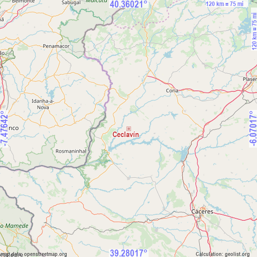
Ceclavín GPS coordinates[2]
39° 49' 20.316" North, 6° 46' 23.844" West
| Map corner | latitude | longitude |
|---|---|---|
| Upper-left | 40.36021°, | -7.47642° |
| Center: | 39.82231°, | -6.77329° |
| Lower-right: | 39.28017°, | -6.07017° |
| Map W x H: | 120.1×120.1 km | = 74.6×74.6mi |
| max Lat: | 43.74134° ⇑72.6% North |
| Ceclavín: | 39.82231° |
| min Lat: | ⇓27.4% South 27.64134° |
| min Long | Ceclavín | max Long |
| -18.00367° | -6.77329° | 4.2899° |
| W 6.7%⇐ | ⇒93.3% E |
Elevation
Elevation of Ceclavín is 332 m = 1089 ft, and this is 266 m = 873 ft below average elevation for this country.
| Max E: |
1682 m = 5518 ft | 73% |
| Avg. | 598 m = 1962 ft | |
| Ceclavín | 332 m = 1089 ft | |
Min E: |
0 m = 0 ft | 27% |
See also: Spain elevation on elevation.city.
Geographical zone
Ceclavín is located in North temperate zone (between Tropic of Cancer and the Arctic Circle). Distance of this Northern Tropic circle is 1821.9 km =1132.1 mi to South.| Distance of | km | miles | from Ceclavín |
|---|---|---|---|
| North Pole | 5579.2 | 3466.8 | to North |
| Arctic Circle | 2973.3 | 1847.5 | to North |
| Tropic Cancer | 1821.9 | 1132.1 | to South |
| Equator | 4427.8 | 2751.3 | to South |


Nearby cities:
15 places around Ceclavín: (largest is in red/bold)
• Acehuche
12.1 km =7.5 mi,  100°
100°
• Alcántara
14.9 km =9.3 mi,  219°
219°
• Brozas
23.3 km =14.5 mi,  180°
180°
• Cachorrilla
13.7 km =8.5 mi,  40°
40°
• Casas de Don Gómez
25.5 km =15.8 mi, 35°
• Casillas de Coria
19.7 km =12.2 mi, 36°
• Garrovillas
22.7 km =14.1 mi,  123°
123°
• Mata de Alcántara
12.3 km =7.6 mi,  198°
198°
• Navas del Madroño
24.5 km =15.2 mi,  155°
155°
• Pescueza
15.2 km =9.4 mi,  45°
45°
• Piedras Albas
13.7 km =8.5 mi,  251°
251°
• Portaje
20.9 km =13 mi,  59°
59°
• Portezuelo
25.6 km =15.9 mi,  92°
92°
• Villa del Rey
18.6 km =11.6 mi,  192°
192°
• Zarza la Mayor
9.7 km =6 mi,  308°
308°
Sources, notices
• [Note1] Compared only with cities in Spain existing in our database
• [Src1] Map data: © OpenStreetMap contributors (CC-BY-SA)
• [Src2] Other city data from geonames.org with taken over terms of usage.
• [Src3] Geographical zone / Annual Mean Temperature by Robert A. Rohde @ Wikipedia
