Brozas geodata
Brozas (Extremadura) is a populated place; located in Spain in Europe/Madrid (GMT+2) time zone. With population of 2,100 people, there are 2099 cities with bigger population in this country. Compared to other cities in Spain, 75.6% of cities are located further ↑North; 93.3% of cities are located further →East and 68.4% of cities have higher elevation than Brozas. Note1


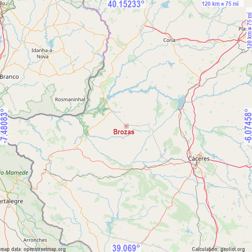
Brozas GPS coordinates[2]
39° 36' 46.008" North, 6° 46' 39.72" West
| Map corner | latitude | longitude |
|---|---|---|
| Upper-left | 40.15233°, | -7.48083° |
| Center: | 39.61278°, | -6.7777° |
| Lower-right: | 39.069°, | -6.07458° |
| Map W x H: | 120.5×120.5 km | = 74.9×74.9mi |
| max Lat: | 43.74134° ⇑75.6% North |
| Brozas: | 39.61278° |
| min Lat: | ⇓24.4% South 27.64134° |
| min Long | Brozas | max Long |
| -18.00367° | -6.7777° | 4.2899° |
| W 6.7%⇐ | ⇒93.3% E |
Elevation
Elevation of Brozas is 409 m = 1342 ft, and this is 189 m = 620 ft below average elevation for this country.
| Max E: |
1682 m = 5518 ft | 68.4% |
| Avg. | 598 m = 1962 ft | |
| Brozas | 409 m = 1342 ft | |
Min E: |
0 m = 0 ft | 31.6% |
See also: Spain elevation on elevation.city.
Geographical zone
Brozas is located in North temperate zone (between Tropic of Cancer and the Arctic Circle). Distance of this Northern Tropic circle is 1798.6 km =1117.6 mi to South.| Distance of | km | miles | from Brozas |
|---|---|---|---|
| North Pole | 5602.5 | 3481.2 | to North |
| Arctic Circle | 2996.6 | 1862 | to North |
| Tropic Cancer | 1798.6 | 1117.6 | to South |
| Equator | 4404.5 | 2736.8 | to South |


Nearby cities:
15 places around Brozas: (largest is in red/bold)
• Acehuche
24.4 km =15.2 mi,  30°
30°
• Alcántara
14.9 km =9.3 mi,  322°
322°
• Aliseda
22.3 km =13.9 mi,  160°
160°
• Arroyo de la Luz
21.8 km =13.5 mi,  130°
130°
• Casar de Cáceres
31.2 km =19.4 mi,  100°
100°
• Ceclavín
23.3 km =14.5 mi,  0°
0°
• Garrovillas
22.3 km =13.9 mi,  60°
60°
• Malpartida de Cáceres
29.6 km =18.4 mi, 128°
• Mata de Alcántara
12.1 km =7.5 mi,  343°
343°
• Membrío
25.5 km =15.8 mi,  248°
248°
• Navas del Madroño
10.8 km =6.7 mi,  84°
84°
• Piedras Albas
22.9 km =14.2 mi,  326°
326°
• Salorino
24.6 km =15.3 mi,  233°
233°
• Villa del Rey
6.4 km =4 mi, 324°
• Zarza la Mayor
30.2 km =18.8 mi,  346°
346°
Sources, notices
• [Note1] Compared only with cities in Spain existing in our database
• [Src1] Map data: © OpenStreetMap contributors (CC-BY-SA)
• [Src2] Other city data from geonames.org with taken over terms of usage.
• [Src3] Geographical zone / Annual Mean Temperature by Robert A. Rohde @ Wikipedia
