Galera geodata
Galera (Andalusia) is a seat of a third-order administrative division; located in Spain in Europe/Madrid (GMT+2) time zone. With population of 1,112 people, there are 2810 cities with bigger population in this country. Compared to other cities in Spain, 89.9% of cities are located further ↑North; 60.4% of cities are located further ←West and 73.5% of cities have lower elevation than Galera. Note1


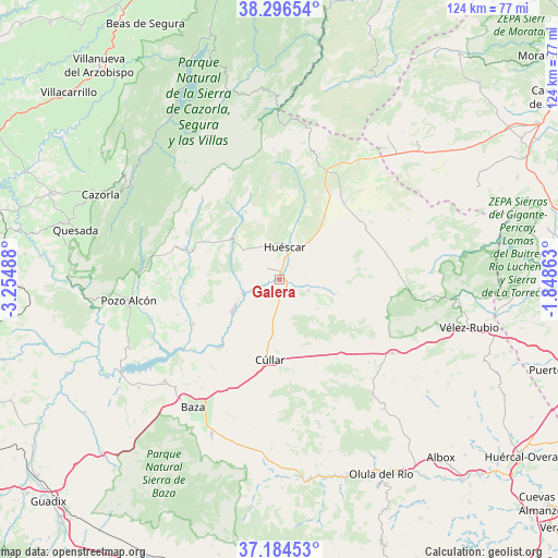
Galera GPS coordinates[2]
37° 44' 33.432" North, 2° 33' 6.3" West
| Map corner | latitude | longitude |
|---|---|---|
| Upper-left | 38.29654°, | -3.25488° |
| Center: | 37.74262°, | -2.55175° |
| Lower-right: | 37.18453°, | -1.84863° |
| Map W x H: | 123.6×123.6 km | = 76.8×76.8mi |
| max Lat: | 43.74134° ⇑89.9% North |
| Galera: | 37.74262° |
| min Lat: | ⇓10.1% South 27.64134° |
| min Long | Galera | max Long |
| -18.00367° | -2.55175° | 4.2899° |
| W 60.4%⇐ | ⇒39.6% E |
Elevation
Elevation of Galera is 839 m = 2753 ft, and this is 241 m = 791 ft above average elevation for this country.
| Max E: |
1682 m = 5518 ft | 26.5% |
| Galera | 839 m 2753 ft | |
| Avg. | 598 m = 1962 ft | |
Min E: |
0 m = 0 ft | 73.5% |
See also: Spain elevation on elevation.city.
Geographical zone
Galera is located in North temperate zone (between Tropic of Cancer and the Arctic Circle). Distance of this Northern Tropic circle is 1590.7 km =988.4 mi to South.| Distance of | km | miles | from Galera |
|---|---|---|---|
| North Pole | 5810.5 | 3610.5 | to North |
| Arctic Circle | 3204.6 | 1991.2 | to North |
| Tropic Cancer | 1590.7 | 988.4 | to South |
| Equator | 4196.6 | 2607.6 | to South |


Nearby cities:
15 places around Galera: (largest is in red/bold)
• Baza
34.1 km =21.2 mi,  214°
214°
• Benamaurel
20 km =12.4 mi,  221°
221°
• Caniles
37.3 km =23.2 mi,  204°
204°
• Castilléjar
8.3 km =5.2 mi,  249°
249°
• Castril
20.9 km =13 mi,  286°
286°
• Chirivel
29.8 km =18.5 mi,  123°
123°
• Cortes de Baza
21.7 km =13.5 mi,  243°
243°
• Cuevas del Campo
36.5 km =22.7 mi, 245°
• Huéscar
7.7 km =4.8 mi,  6°
6°
• María
34.2 km =21.3 mi,  96°
96°
• Orce
6.9 km =4.3 mi,  110°
110°
• Oria
36.6 km =22.7 mi,  141°
141°
• Pozo Alcón
33.9 km =21.1 mi,  262°
262°
• Puebla de Don Fadrique
26.3 km =16.3 mi,  22°
22°
• Zújar
33.9 km =21.1 mi,  228°
228°
Sources, notices
• [Note1] Compared only with cities in Spain existing in our database
• [Src1] Map data: © OpenStreetMap contributors (CC-BY-SA)
• [Src2] Other city data from geonames.org with taken over terms of usage.
• [Src3] Geographical zone / Annual Mean Temperature by Robert A. Rohde @ Wikipedia
