Benamaurel geodata
Benamaurel (Andalusia) is a seat of a third-order administrative division; located in Spain in Europe/Madrid (GMT+2) time zone. With population of 2,293 people, there are 2005 cities with bigger population in this country. Compared to other cities in Spain, 90.7% of cities are located further ↑North; 58.6% of cities are located further ←West and 53.7% of cities have lower elevation than Benamaurel. Note1


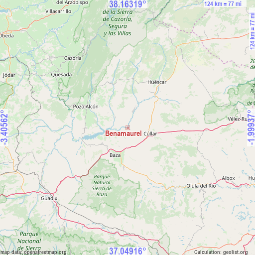
Benamaurel GPS coordinates[2]
37° 36' 29.736" North, 2° 42' 9" West
| Map corner | latitude | longitude |
|---|---|---|
| Upper-left | 38.16319°, | -3.40562° |
| Center: | 37.60826°, | -2.7025° |
| Lower-right: | 37.04916°, | -1.99937° |
| Map W x H: | 123.9×123.9 km | = 77×77mi |
| max Lat: | 43.74134° ⇑90.7% North |
| Benamaurel: | 37.60826° |
| min Lat: | ⇓9.3% South 27.64134° |
| min Long | Benamaurel | max Long |
| -18.00367° | -2.7025° | 4.2899° |
| W 58.6%⇐ | ⇒41.4% E |
Elevation
Elevation of Benamaurel is 697 m = 2287 ft, and this is 99 m = 325 ft above average elevation for this country.
| Max E: |
1682 m = 5518 ft | 46.3% |
| Benamaurel | 697 m 2287 ft | |
| Avg. | 598 m = 1962 ft | |
Min E: |
0 m = 0 ft | 53.7% |
See also: Spain elevation on elevation.city.
Geographical zone
Benamaurel is located in North temperate zone (between Tropic of Cancer and the Arctic Circle). Distance of this Northern Tropic circle is 1575.7 km =979.1 mi to South.| Distance of | km | miles | from Benamaurel |
|---|---|---|---|
| North Pole | 5825.4 | 3619.7 | to North |
| Arctic Circle | 3219.5 | 2000.5 | to North |
| Tropic Cancer | 1575.7 | 979.1 | to South |
| Equator | 4181.6 | 2598.3 | to South |


Nearby cities:
15 places around Benamaurel: (largest is in red/bold)
• Alcóntar
31.6 km =19.6 mi,  162°
162°
• Baza
14.5 km =9 mi,  205°
205°
• Caniles
19.2 km =11.9 mi,  185°
185°
• Castilléjar
13.3 km =8.3 mi,  24°
24°
• Castril
21.9 km =13.6 mi,  341°
341°
• Cortes de Baza
8 km =5 mi,  310°
310°
• Cuevas del Campo
20 km =12.4 mi,  269°
269°
• Freila
20.1 km =12.5 mi,  244°
244°
• Galera
20 km =12.4 mi,  41°
41°
• Gorafe
33.2 km =20.6 mi, 244°
• Hinojares
28.6 km =17.8 mi,  294°
294°
• Huéscar
26.6 km =16.5 mi,  32°
32°
• Orce
23.4 km =14.5 mi,  57°
57°
• Pozo Alcón
22.9 km =14.2 mi,  297°
297°
• Zújar
14.3 km =8.9 mi, 239°
Sources, notices
• [Note1] Compared only with cities in Spain existing in our database
• [Src1] Map data: © OpenStreetMap contributors (CC-BY-SA)
• [Src2] Other city data from geonames.org with taken over terms of usage.
• [Src3] Geographical zone / Annual Mean Temperature by Robert A. Rohde @ Wikipedia
