Caniles geodata
Caniles (Andalusia) is a populated place; located in Spain in Europe/Madrid (GMT+2) time zone. With population of 4,851 people, there are 1337 cities with bigger population in this country. Compared to other cities in Spain, 91.6% of cities are located further ↑North; 58.4% of cities are located further ←West and 82% of cities have lower elevation than Caniles. Note1


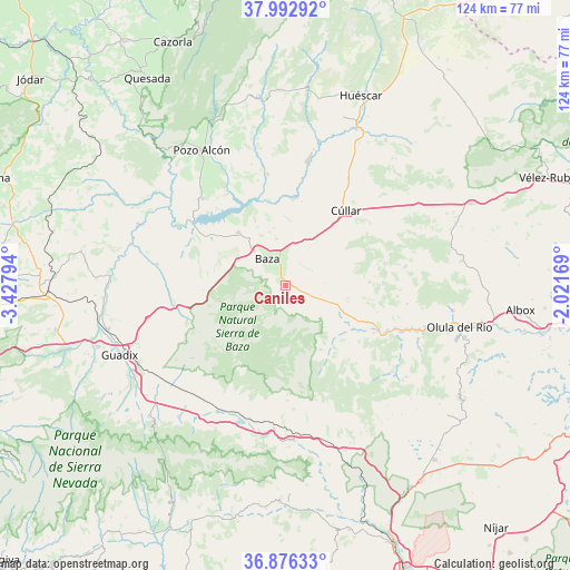
Caniles GPS coordinates[2]
37° 26' 12.156" North, 2° 43' 29.352" West
| Map corner | latitude | longitude |
|---|---|---|
| Upper-left | 37.99292°, | -3.42794° |
| Center: | 37.43671°, | -2.72482° |
| Lower-right: | 36.87633°, | -2.02169° |
| Map W x H: | 124.2×124.2 km | = 77.2×77.2mi |
| max Lat: | 43.74134° ⇑91.6% North |
| Caniles: | 37.43671° |
| min Lat: | ⇓8.4% South 27.64134° |
| min Long | Caniles | max Long |
| -18.00367° | -2.72482° | 4.2899° |
| W 58.4%⇐ | ⇒41.6% E |
Elevation
Elevation of Caniles is 917 m = 3009 ft, and this is 319 m = 1047 ft above average elevation for this country.
| Max E: |
1682 m = 5518 ft | 18% |
| Caniles | 917 m 3009 ft | |
| Avg. | 598 m = 1962 ft | |
Min E: |
0 m = 0 ft | 82% |
See also: Spain elevation on elevation.city.
Geographical zone
Caniles is located in North temperate zone (between Tropic of Cancer and the Arctic Circle). Distance of this Northern Tropic circle is 1556.7 km =967.3 mi to South.| Distance of | km | miles | from Caniles |
|---|---|---|---|
| North Pole | 5844.5 | 3631.6 | to North |
| Arctic Circle | 3238.6 | 2012.4 | to North |
| Tropic Cancer | 1556.7 | 967.3 | to South |
| Equator | 4162.6 | 2586.5 | to South |


Nearby cities:
15 places around Caniles: (largest is in red/bold)
• Alcóntar
15.9 km =9.9 mi,  134°
134°
• Armuña de Almanzora
29.3 km =18.2 mi,  109°
109°
• Bayarque
28.1 km =17.5 mi, 114°
• Baza
7.3 km =4.5 mi,  324°
324°
• Benamaurel
19.2 km =11.9 mi,  5°
5°
• Cortes de Baza
24.6 km =15.3 mi,  350°
350°
• Cuevas del Campo
26.2 km =16.3 mi, 316°
• Freila
19.2 km =11.9 mi,  302°
302°
• Gor
22.9 km =14.2 mi,  250°
250°
• Gorafe
28.4 km =17.6 mi,  279°
279°
• Lúcar
26.8 km =16.7 mi,  98°
98°
• Serón
21.6 km =13.4 mi,  118°
118°
• Somontín
30.1 km =18.7 mi, 99°
• Tíjola
27.7 km =17.2 mi, 111°
• Zújar
15.7 km =9.8 mi, 318°
Sources, notices
• [Note1] Compared only with cities in Spain existing in our database
• [Src1] Map data: © OpenStreetMap contributors (CC-BY-SA)
• [Src2] Other city data from geonames.org with taken over terms of usage.
• [Src3] Geographical zone / Annual Mean Temperature by Robert A. Rohde @ Wikipedia
