Estellencs geodata
Estellencs (Balearic Islands) is a seat of a third-order administrative division; located in Spain in Europe/Madrid (GMT+2) time zone. With population of 386 people, there are 4179 cities with bigger population in this country. Compared to other cities in Spain, 75% of cities are located further ↑North; 96.4% of cities are located further ←West and 84.3% of cities have higher elevation than Estellencs. Note1


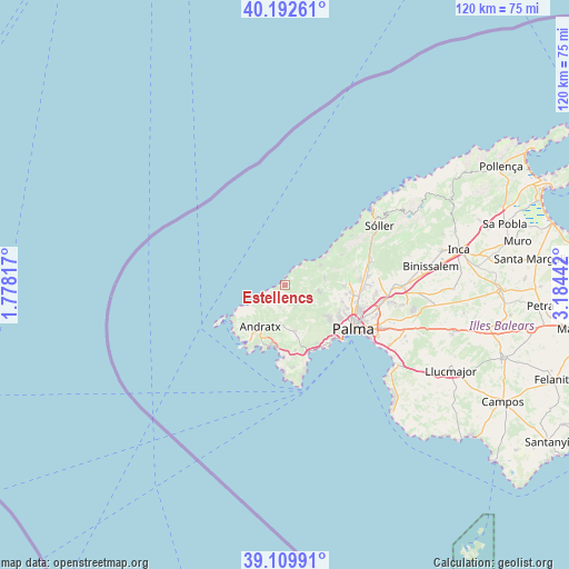
Estellencs GPS coordinates[2]
39° 39' 12.168" North, 2° 28' 52.68" East
| Map corner | latitude | longitude |
|---|---|---|
| Upper-left | 40.19261°, | 1.77817° |
| Center: | 39.65338°, | 2.4813° |
| Lower-right: | 39.10991°, | 3.18442° |
| Map W x H: | 120.4×120.4 km | = 74.8×74.8mi |
| max Lat: | 43.74134° ⇑75% North |
| Estellencs: | 39.65338° |
| min Lat: | ⇓25% South 27.64134° |
| min Long | Estellencs | max Long |
| -18.00367° | 2.4813° | 4.2899° |
| W 96.4%⇐ | ⇒3.6% E |
Elevation
Elevation of Estellencs is 151 m = 495 ft, and this is 447 m = 1467 ft below average elevation for this country.
| Max E: |
1682 m = 5518 ft | 84.3% |
| Avg. | 598 m = 1962 ft | |
| Estellencs | 151 m = 495 ft | |
Min E: |
0 m = 0 ft | 15.7% |
See also: Spain elevation on elevation.city.
Geographical zone
Estellencs is located in North temperate zone (between Tropic of Cancer and the Arctic Circle). Distance of this Northern Tropic circle is 1803.1 km =1120.4 mi to South.| Distance of | km | miles | from Estellencs |
|---|---|---|---|
| North Pole | 5598 | 3478.4 | to North |
| Arctic Circle | 2992.1 | 1859.2 | to North |
| Tropic Cancer | 1803.1 | 1120.4 | to South |
| Equator | 4409 | 2739.6 | to South |


Nearby cities:
15 places around Estellencs: (largest is in red/bold)
• Andratx
10.1 km =6.3 mi,  211°
211°
• Banyalbufar
4.7 km =2.9 mi,  36°
36°
• Calvià
10 km =6.2 mi,  167°
167°
• Camp de Mar
13.7 km =8.5 mi,  201°
201°
• Deià
17.7 km =11 mi,  53°
53°
• El Toro
18.7 km =11.6 mi,  179°
179°
• Esporles
8.5 km =5.3 mi,  79°
79°
• Magaluf
16.5 km =10.3 mi,  163°
163°
• Palma
17.2 km =10.7 mi,  122°
122°
• Palmanova
15.1 km =9.4 mi, 160°
• Peguera
13.2 km =8.2 mi,  192°
192°
• Puigpunyent
5.1 km =3.2 mi,  128°
128°
• Santa Ponsa
16.1 km =10 mi, 181°
• Son Ferrer
17.5 km =10.9 mi, 174°
• Valldemossa
13.6 km =8.5 mi,  62°
62°
Sources, notices
• [Note1] Compared only with cities in Spain existing in our database
• [Src1] Map data: © OpenStreetMap contributors (CC-BY-SA)
• [Src2] Other city data from geonames.org with taken over terms of usage.
• [Src3] Geographical zone / Annual Mean Temperature by Robert A. Rohde @ Wikipedia
