Peguera geodata
Peguera (Balearic Islands) is a populated place; located in Spain in Europe/Madrid (GMT+2) time zone. With population of 3,988 people, there are 1479 cities with bigger population in this country. Compared to other cities in Spain, 76.5% of cities are located further ↑North; 96.3% of cities are located further ←West and 98.9% of cities have higher elevation than Peguera. Note1


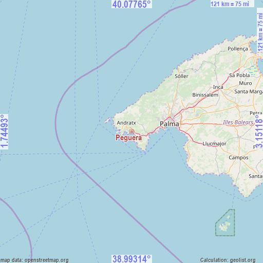
Peguera GPS coordinates[2]
39° 32' 15.036" North, 2° 26' 53.016" East
| Map corner | latitude | longitude |
|---|---|---|
| Upper-left | 40.07765°, | 1.74493° |
| Center: | 39.53751°, | 2.44806° |
| Lower-right: | 38.99314°, | 3.15118° |
| Map W x H: | 120.6×120.6 km | = 74.9×74.9mi |
| max Lat: | 43.74134° ⇑76.5% North |
| Peguera: | 39.53751° |
| min Lat: | ⇓23.5% South 27.64134° |
| min Long | Peguera | max Long |
| -18.00367° | 2.44806° | 4.2899° |
| W 96.3%⇐ | ⇒3.7% E |
Elevation
Elevation of Peguera is 8 m = 26 ft, and this is 590 m = 1936 ft below average elevation for this country.
| Max E: |
1682 m = 5518 ft | 98.9% |
| Avg. | 598 m = 1962 ft | |
| Peguera | 8 m = 26 ft | |
Min E: |
0 m = 0 ft | 1.1% |
See also: Spain elevation on elevation.city.
Geographical zone
Peguera is located in North temperate zone (between Tropic of Cancer and the Arctic Circle). Distance of this Northern Tropic circle is 1790.2 km =1112.4 mi to South.| Distance of | km | miles | from Peguera |
|---|---|---|---|
| North Pole | 5610.9 | 3486.5 | to North |
| Arctic Circle | 3005 | 1867.2 | to North |
| Tropic Cancer | 1790.2 | 1112.4 | to South |
| Equator | 4396.2 | 2731.7 | to South |


Nearby cities:
15 places around Peguera: (largest is in red/bold)
• Andratx
4.9 km =3 mi,  330°
330°
• Banyalbufar
17.6 km =10.9 mi,  18°
18°
• Calvià
5.9 km =3.7 mi,  57°
57°
• Camp de Mar
2.1 km =1.3 mi,  272°
272°
• Coll d'en Rabassa
21.2 km =13.2 mi,  85°
85°
• El Toro
6.6 km =4.1 mi,  153°
153°
• Es Molinar
19.7 km =12.2 mi,  82°
82°
• Esporles
18.3 km =11.4 mi,  37°
37°
• Estellencs
13.2 km =8.2 mi,  12°
12°
• Magaluf
8 km =5 mi,  111°
111°
• Palma
17.7 km =11 mi, 78°
• Palmanova
7.9 km =4.9 mi,  100°
100°
• Puigpunyent
11.9 km =7.4 mi,  34°
34°
• Santa Ponsa
4 km =2.5 mi,  142°
142°
• Son Ferrer
6.4 km =4 mi,  134°
134°
Sources, notices
• [Note1] Compared only with cities in Spain existing in our database
• [Src1] Map data: © OpenStreetMap contributors (CC-BY-SA)
• [Src2] Other city data from geonames.org with taken over terms of usage.
• [Src3] Geographical zone / Annual Mean Temperature by Robert A. Rohde @ Wikipedia
