Banyalbufar geodata
Banyalbufar (Balearic Islands) is a seat of a third-order administrative division; located in Spain in Europe/Madrid (GMT+2) time zone. With population of 568 people, there are 3684 cities with bigger population in this country. Compared to other cities in Spain, 74.6% of cities are located further ↑North; 96.6% of cities are located further ←West and 87% of cities have higher elevation than Banyalbufar. Note1


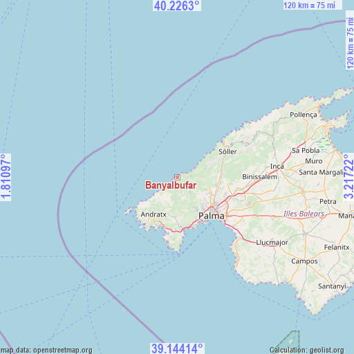
Banyalbufar GPS coordinates[2]
39° 41' 14.424" North, 2° 30' 50.724" East
| Map corner | latitude | longitude |
|---|---|---|
| Upper-left | 40.2263°, | 1.81097° |
| Center: | 39.68734°, | 2.51409° |
| Lower-right: | 39.14414°, | 3.21722° |
| Map W x H: | 120.3×120.3 km | = 74.8×74.8mi |
| max Lat: | 43.74134° ⇑74.6% North |
| Banyalbufar: | 39.68734° |
| min Lat: | ⇓25.4% South 27.64134° |
| min Long | Banyalbufar | max Long |
| -18.00367° | 2.51409° | 4.2899° |
| W 96.6%⇐ | ⇒3.4% E |
Elevation
Elevation of Banyalbufar is 110 m = 361 ft, and this is 488 m = 1601 ft below average elevation for this country.
| Max E: |
1682 m = 5518 ft | 87% |
| Avg. | 598 m = 1962 ft | |
| Banyalbufar | 110 m = 361 ft | |
Min E: |
0 m = 0 ft | 13% |
See also: Spain elevation on elevation.city.
Geographical zone
Banyalbufar is located in North temperate zone (between Tropic of Cancer and the Arctic Circle). Distance of this Northern Tropic circle is 1806.9 km =1122.8 mi to South.| Distance of | km | miles | from Banyalbufar |
|---|---|---|---|
| North Pole | 5594.2 | 3476.1 | to North |
| Arctic Circle | 2988.4 | 1856.9 | to North |
| Tropic Cancer | 1806.9 | 1122.8 | to South |
| Equator | 4412.8 | 2742 | to South |


Nearby cities:
15 places around Banyalbufar: (largest is in red/bold)
• Andratx
14.8 km =9.2 mi,  212°
212°
• Bunyola
15.9 km =9.9 mi,  86°
86°
• Calvià
13.5 km =8.4 mi,  182°
182°
• Camp de Mar
18.3 km =11.4 mi,  204°
204°
• Deià
13.3 km =8.3 mi,  59°
59°
• Es Molinar
19.7 km =12.2 mi,  135°
135°
• Esporles
5.9 km =3.7 mi,  111°
111°
• Estellencs
4.7 km =2.9 mi,  216°
216°
• Marratxí
19.5 km =12.1 mi, 112°
• Palma
17.5 km =10.9 mi, 138°
• Palmanova
18.2 km =11.3 mi,  173°
173°
• Peguera
17.6 km =10.9 mi, 198°
• Puigpunyent
7 km =4.3 mi, 170°
• Sóller
19.3 km =12 mi, 62°
• Valldemossa
9.6 km =6 mi,  74°
74°
Sources, notices
• [Note1] Compared only with cities in Spain existing in our database
• [Src1] Map data: © OpenStreetMap contributors (CC-BY-SA)
• [Src2] Other city data from geonames.org with taken over terms of usage.
• [Src3] Geographical zone / Annual Mean Temperature by Robert A. Rohde @ Wikipedia
