Santa Ponsa geodata
Santa Ponsa (Balearic Islands) is a populated place; located in Spain in Europe/Madrid (GMT+2) time zone. With population of 10,736 people, there are 814 cities with bigger population in this country. Compared to other cities in Spain, 76.8% of cities are located further ↑North; 96.4% of cities are located further ←West and 93.6% of cities have higher elevation than Santa Ponsa. Note1


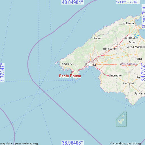
Santa Ponsa GPS coordinates[2]
39° 30' 31.248" North, 2° 28' 35.76" East
| Map corner | latitude | longitude |
|---|---|---|
| Upper-left | 40.04904°, | 1.77347° |
| Center: | 39.50868°, | 2.4766° |
| Lower-right: | 38.96408°, | 3.17972° |
| Map W x H: | 120.6×120.6 km | = 74.9×74.9mi |
| max Lat: | 43.74134° ⇑76.8% North |
| Santa Ponsa: | 39.50868° |
| min Lat: | ⇓23.2% South 27.64134° |
| min Long | Santa Ponsa | max Long |
| -18.00367° | 2.4766° | 4.2899° |
| W 96.4%⇐ | ⇒3.6% E |
Elevation
Elevation of Santa Ponsa is 34 m = 112 ft, and this is 564 m = 1850 ft below average elevation for this country.
| Max E: |
1682 m = 5518 ft | 93.6% |
| Avg. | 598 m = 1962 ft | |
| Santa Ponsa | 34 m = 112 ft | |
Min E: |
0 m = 0 ft | 6.4% |
See also: Spain elevation on elevation.city.
Geographical zone
Santa Ponsa is located in North temperate zone (between Tropic of Cancer and the Arctic Circle). Distance of this Northern Tropic circle is 1787 km =1110.4 mi to South.| Distance of | km | miles | from Santa Ponsa |
|---|---|---|---|
| North Pole | 5614.1 | 3488.4 | to North |
| Arctic Circle | 3008.2 | 1869.2 | to North |
| Tropic Cancer | 1787 | 1110.4 | to South |
| Equator | 4393 | 2729.7 | to South |


Nearby cities:
15 places around Santa Ponsa: (largest is in red/bold)
• Andratx
8.9 km =5.5 mi,  326°
326°
• Banyalbufar
20.1 km =12.5 mi,  9°
9°
• Calvià
6.8 km =4.2 mi,  21°
21°
• Camp de Mar
5.6 km =3.5 mi,  306°
306°
• Coll d'en Rabassa
19.3 km =12 mi,  75°
75°
• El Toro
2.7 km =1.7 mi,  169°
169°
• Es Molinar
18 km =11.2 mi,  71°
71°
• Esporles
19.8 km =12.3 mi,  26°
26°
• Estellencs
16.1 km =10 mi,  1°
1°
• Magaluf
5 km =3.1 mi,  86°
86°
• Palma
16.3 km =10.1 mi, 65°
• Palmanova
5.7 km =3.5 mi, 71°
• Peguera
4 km =2.5 mi,  322°
322°
• Puigpunyent
13.7 km =8.5 mi, 18°
• Son Ferrer
2.5 km =1.6 mi,  122°
122°
Sources, notices
• [Note1] Compared only with cities in Spain existing in our database
• [Src1] Map data: © OpenStreetMap contributors (CC-BY-SA)
• [Src2] Other city data from geonames.org with taken over terms of usage.
• [Src3] Geographical zone / Annual Mean Temperature by Robert A. Rohde @ Wikipedia
