Búger geodata
Búger (Balearic Islands) is a seat of a third-order administrative division; located in Spain in Europe/Madrid (GMT+2) time zone. With population of 1,016 people, there are 2920 cities with bigger population in this country. Compared to other cities in Spain, 73.5% of cities are located further ↑North; 98.6% of cities are located further ←West and 88.3% of cities have higher elevation than Búger. Note1


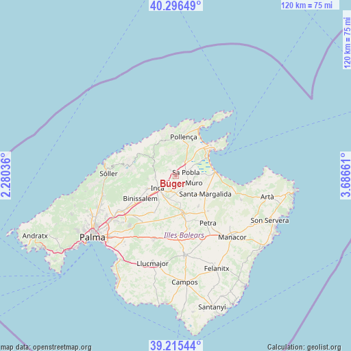
Búger GPS coordinates[2]
39° 45' 29.124" North, 2° 59' 0.564" East
| Map corner | latitude | longitude |
|---|---|---|
| Upper-left | 40.29649°, | 2.28036° |
| Center: | 39.75809°, | 2.98349° |
| Lower-right: | 39.21544°, | 3.68661° |
| Map W x H: | 120.2×120.2 km | = 74.7×74.7mi |
| max Lat: | 43.74134° ⇑73.5% North |
| Búger: | 39.75809° |
| min Lat: | ⇓26.5% South 27.64134° |
| min Long | Búger | max Long |
| -18.00367° | 2.98349° | 4.2899° |
| W 98.6%⇐ | ⇒1.4% E |
Elevation
Elevation of Búger is 91 m = 299 ft, and this is 507 m = 1663 ft below average elevation for this country.
| Max E: |
1682 m = 5518 ft | 88.3% |
| Avg. | 598 m = 1962 ft | |
| Búger | 91 m = 299 ft | |
Min E: |
0 m = 0 ft | 11.7% |
See also: Spain elevation on elevation.city.
Geographical zone
Búger is located in North temperate zone (between Tropic of Cancer and the Arctic Circle). Distance of this Northern Tropic circle is 1814.8 km =1127.7 mi to South.| Distance of | km | miles | from Búger |
|---|---|---|---|
| North Pole | 5586.4 | 3471.2 | to North |
| Arctic Circle | 2980.5 | 1852 | to North |
| Tropic Cancer | 1814.8 | 1127.7 | to South |
| Equator | 4420.7 | 2746.9 | to South |


Nearby cities:
15 places around Búger: (largest is in red/bold)
• Binissalem
14.3 km =8.9 mi,  236°
236°
• Campanet
2.4 km =1.5 mi,  319°
319°
• Costitx
11.6 km =7.2 mi,  194°
194°
• Escorca
12 km =7.5 mi,  305°
305°
• Inca
7.4 km =4.6 mi, 236°
• Lloseta
10.9 km =6.8 mi,  246°
246°
• Llubí
6.8 km =4.2 mi,  163°
163°
• Mancor de la Vall
9.5 km =5.9 mi,  264°
264°
• Maria de la Salut
13 km =8.1 mi,  144°
144°
• Muro
6.6 km =4.1 mi,  111°
111°
• Pollença
13.5 km =8.4 mi,  11°
11°
• Santa Margalida
11.9 km =7.4 mi,  121°
121°
• Selva
7.1 km =4.4 mi,  267°
267°
• Sineu
13.1 km =8.1 mi,  169°
169°
• sa Pobla
3.7 km =2.3 mi,  70°
70°
Sources, notices
• [Note1] Compared only with cities in Spain existing in our database
• [Src1] Map data: © OpenStreetMap contributors (CC-BY-SA)
• [Src2] Other city data from geonames.org with taken over terms of usage.
• [Src3] Geographical zone / Annual Mean Temperature by Robert A. Rohde @ Wikipedia
