Campanet geodata
Campanet (Balearic Islands) is a seat of a third-order administrative division; located in Spain in Europe/Madrid (GMT+2) time zone. With population of 2,515 people, there are 1897 cities with bigger population in this country. Compared to other cities in Spain, 73.2% of cities are located further ↑North; 98.4% of cities are located further ←West and 85.4% of cities have higher elevation than Campanet. Note1


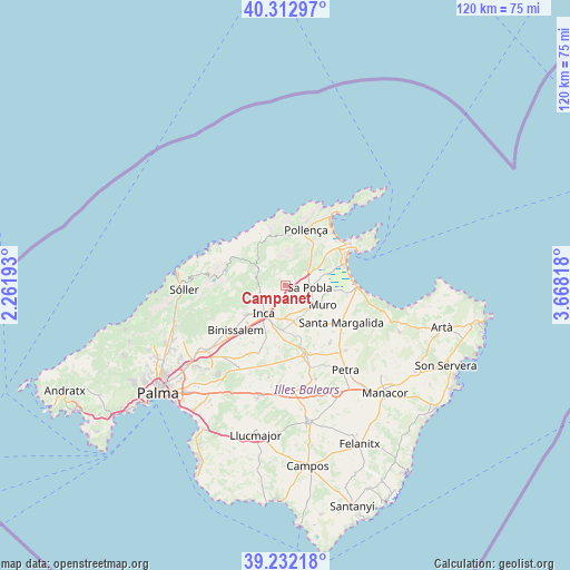
Campanet GPS coordinates[2]
39° 46' 28.92" North, 2° 57' 54.216" East
| Map corner | latitude | longitude |
|---|---|---|
| Upper-left | 40.31297°, | 2.26193° |
| Center: | 39.7747°, | 2.96506° |
| Lower-right: | 39.23218°, | 3.66818° |
| Map W x H: | 120.2×120.2 km | = 74.7×74.7mi |
| max Lat: | 43.74134° ⇑73.2% North |
| Campanet: | 39.7747° |
| min Lat: | ⇓26.8% South 27.64134° |
| min Long | Campanet | max Long |
| -18.00367° | 2.96506° | 4.2899° |
| W 98.4%⇐ | ⇒1.6% E |
Elevation
Elevation of Campanet is 132 m = 433 ft, and this is 466 m = 1529 ft below average elevation for this country.
| Max E: |
1682 m = 5518 ft | 85.4% |
| Avg. | 598 m = 1962 ft | |
| Campanet | 132 m = 433 ft | |
Min E: |
0 m = 0 ft | 14.6% |
See also: Spain elevation on elevation.city.
Geographical zone
Campanet is located in North temperate zone (between Tropic of Cancer and the Arctic Circle). Distance of this Northern Tropic circle is 1816.6 km =1128.8 mi to South.| Distance of | km | miles | from Campanet |
|---|---|---|---|
| North Pole | 5584.5 | 3470 | to North |
| Arctic Circle | 2978.6 | 1850.8 | to North |
| Tropic Cancer | 1816.6 | 1128.8 | to South |
| Equator | 4422.5 | 2748 | to South |


Nearby cities:
15 places around Campanet: (largest is in red/bold)
• Binissalem
14.2 km =8.8 mi,  226°
226°
• Búger
2.4 km =1.5 mi,  139°
139°
• Costitx
13.2 km =8.2 mi,  185°
185°
• Escorca
9.7 km =6 mi,  302°
302°
• Inca
7.5 km =4.7 mi,  217°
217°
• Lloseta
10.5 km =6.5 mi, 233°
• Llubí
9.1 km =5.7 mi,  156°
156°
• Mancor de la Vall
8.4 km =5.2 mi,  250°
250°
• Muro
8.8 km =5.5 mi,  118°
118°
• Pollença
12.2 km =7.6 mi,  21°
21°
• Santa Margalida
14.3 km =8.9 mi, 124°
• Selva
5.9 km =3.7 mi, 248°
• Sencelles
15.4 km =9.6 mi,  201°
201°
• Sineu
15.2 km =9.4 mi,  165°
165°
• sa Pobla
5.1 km =3.2 mi,  96°
96°
Sources, notices
• [Note1] Compared only with cities in Spain existing in our database
• [Src1] Map data: © OpenStreetMap contributors (CC-BY-SA)
• [Src2] Other city data from geonames.org with taken over terms of usage.
• [Src3] Geographical zone / Annual Mean Temperature by Robert A. Rohde @ Wikipedia
