Alcaucín geodata
Alcaucín (Andalusia) is a seat of a third-order administrative division; located in Spain in Europe/Madrid (GMT+2) time zone. With population of 1,697 people, there are 2340 cities with bigger population in this country. Compared to other cities in Spain, 96.1% of cities are located further ↑North; 61.4% of cities are located further →East and 61% of cities have higher elevation than Alcaucín. Note1


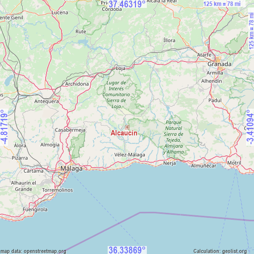
Alcaucín GPS coordinates[2]
36° 54' 10.836" North, 4° 6' 50.616" West
| Map corner | latitude | longitude |
|---|---|---|
| Upper-left | 37.46319°, | -4.81719° |
| Center: | 36.90301°, | -4.11406° |
| Lower-right: | 36.33869°, | -3.41094° |
| Map W x H: | 125×125 km | = 77.7×77.7mi |
| max Lat: | 43.74134° ⇑96.1% North |
| Alcaucín: | 36.90301° |
| min Lat: | ⇓3.9% South 27.64134° |
| min Long | Alcaucín | max Long |
| -18.00367° | -4.11406° | 4.2899° |
| W 38.6%⇐ | ⇒61.4% E |
Elevation
Elevation of Alcaucín is 513 m = 1683 ft, and this is 85 m = 279 ft below average elevation for this country.
| Max E: |
1682 m = 5518 ft | 61% |
| Avg. | 598 m = 1962 ft | |
| Alcaucín | 513 m = 1683 ft | |
Min E: |
0 m = 0 ft | 39% |
See also: Spain elevation on elevation.city.
Geographical zone
Alcaucín is located in North temperate zone (between Tropic of Cancer and the Arctic Circle). Distance of this Northern Tropic circle is 1497.3 km =930.4 mi to South.| Distance of | km | miles | from Alcaucín |
|---|---|---|---|
| North Pole | 5903.8 | 3668.5 | to North |
| Arctic Circle | 3297.9 | 2049.2 | to North |
| Tropic Cancer | 1497.3 | 930.4 | to South |
| Equator | 4103.2 | 2549.6 | to South |


Nearby cities:
15 places around Alcaucín: (largest is in red/bold)
• Almáchar
13.9 km =8.6 mi,  220°
220°
• Arenas
11.5 km =7.1 mi,  147°
147°
• Benamargosa
10.4 km =6.5 mi, 223°
• Benamocarra
13.2 km =8.2 mi,  198°
198°
• Canillas de Aceituno
4.4 km =2.7 mi,  139°
139°
• Canillas de Albaida
12.9 km =8 mi,  118°
118°
• Comares
13.2 km =8.2 mi,  243°
243°
• Cútar
12.9 km =8 mi,  231°
231°
• Periana
7.5 km =4.7 mi,  292°
292°
• Salares
9.6 km =6 mi, 123°
• Sedella
8.5 km =5.3 mi, 122°
• Viñuela
5.1 km =3.2 mi,  208°
208°
• Vélez-Málaga
13.6 km =8.5 mi,  175°
175°
• Zafarraya
8.5 km =5.3 mi,  341°
341°
• Árchez
12.9 km =8 mi, 122°
Sources, notices
• [Note1] Compared only with cities in Spain existing in our database
• [Src1] Map data: © OpenStreetMap contributors (CC-BY-SA)
• [Src2] Other city data from geonames.org with taken over terms of usage.
• [Src3] Geographical zone / Annual Mean Temperature by Robert A. Rohde @ Wikipedia
