Periana geodata
Periana (Andalusia) is a seat of a third-order administrative division; located in Spain in Europe/Madrid (GMT+2) time zone. With population of 3,404 people, there are 1608 cities with bigger population in this country. Compared to other cities in Spain, 95.9% of cities are located further ↑North; 62.5% of cities are located further →East and 56.8% of cities have higher elevation than Periana. Note1


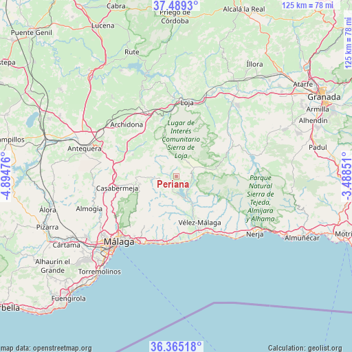
Periana GPS coordinates[2]
36° 55' 45.516" North, 4° 11' 29.868" West
| Map corner | latitude | longitude |
|---|---|---|
| Upper-left | 37.4893°, | -4.89476° |
| Center: | 36.92931°, | -4.19163° |
| Lower-right: | 36.36518°, | -3.48851° |
| Map W x H: | 125×125 km | = 77.7×77.7mi |
| max Lat: | 43.74134° ⇑95.9% North |
| Periana: | 36.92931° |
| min Lat: | ⇓4.1% South 27.64134° |
| min Long | Periana | max Long |
| -18.00367° | -4.19163° | 4.2899° |
| W 37.5%⇐ | ⇒62.5% E |
Elevation
Elevation of Periana is 569 m = 1867 ft, and this is 29 m = 95 ft below average elevation for this country.
| Max E: |
1682 m = 5518 ft | 56.8% |
| Avg. | 598 m = 1962 ft | |
| Periana | 569 m = 1867 ft | |
Min E: |
0 m = 0 ft | 43.2% |
See also: Spain elevation on elevation.city.
Geographical zone
Periana is located in North temperate zone (between Tropic of Cancer and the Arctic Circle). Distance of this Northern Tropic circle is 1500.2 km =932.2 mi to South.| Distance of | km | miles | from Periana |
|---|---|---|---|
| North Pole | 5900.9 | 3666.6 | to North |
| Arctic Circle | 3295 | 2047.4 | to North |
| Tropic Cancer | 1500.2 | 932.2 | to South |
| Equator | 4106.2 | 2551.5 | to South |


Nearby cities:
15 places around Periana: (largest is in red/bold)
• Alcaucín
7.5 km =4.7 mi,  112°
112°
• Alfarnate
9.4 km =5.8 mi,  320°
320°
• Alfarnatejo
9.6 km =6 mi, 320°
• Almáchar
13.6 km =8.5 mi,  189°
189°
• Benamargosa
10.5 km =6.5 mi,  180°
180°
• Benamocarra
15.6 km =9.7 mi,  170°
170°
• Borge
13.3 km =8.3 mi,  196°
196°
• Canillas de Aceituno
11.5 km =7.1 mi,  122°
122°
• Colmenar
13.1 km =8.1 mi,  258°
258°
• Comares
10.2 km =6.3 mi,  208°
208°
• Cútar
11.3 km =7 mi, 196°
• Ríogordo
9.1 km =5.7 mi, 261°
• Sedella
15.9 km =9.9 mi, 117°
• Viñuela
8.6 km =5.3 mi,  148°
148°
• Zafarraya
6.6 km =4.1 mi,  39°
39°
Sources, notices
• [Note1] Compared only with cities in Spain existing in our database
• [Src1] Map data: © OpenStreetMap contributors (CC-BY-SA)
• [Src2] Other city data from geonames.org with taken over terms of usage.
• [Src3] Geographical zone / Annual Mean Temperature by Robert A. Rohde @ Wikipedia
