Hornachuelos geodata
Hornachuelos (Andalusia) is a seat of a third-order administrative division; located in Spain in Europe/Madrid (GMT+2) time zone. With population of 4,667 people, there are 1361 cities with bigger population in this country. Compared to other cities in Spain, 89.5% of cities are located further ↑North; 75.5% of cities are located further →East and 83.3% of cities have higher elevation than Hornachuelos. Note1


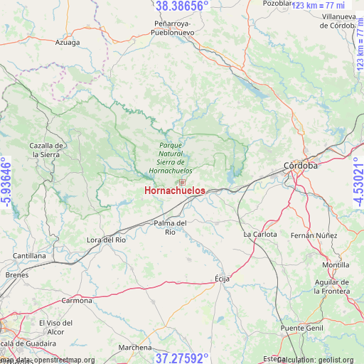
Hornachuelos GPS coordinates[2]
37° 49' 59.988" North, 5° 13' 59.988" West
| Map corner | latitude | longitude |
|---|---|---|
| Upper-left | 38.38656°, | -5.93646° |
| Center: | 37.83333°, | -5.23333° |
| Lower-right: | 37.27592°, | -4.53021° |
| Map W x H: | 123.5×123.5 km | = 76.7×76.7mi |
| max Lat: | 43.74134° ⇑89.5% North |
| Hornachuelos: | 37.83333° |
| min Lat: | ⇓10.5% South 27.64134° |
| min Long | Hornachuelos | max Long |
| -18.00367° | -5.23333° | 4.2899° |
| W 24.5%⇐ | ⇒75.5% E |
Elevation
Elevation of Hornachuelos is 164 m = 538 ft, and this is 434 m = 1424 ft below average elevation for this country.
| Max E: |
1682 m = 5518 ft | 83.3% |
| Avg. | 598 m = 1962 ft | |
| Hornachuelos | 164 m = 538 ft | |
Min E: |
0 m = 0 ft | 16.7% |
See also: Spain elevation on elevation.city.
Geographical zone
Hornachuelos is located in North temperate zone (between Tropic of Cancer and the Arctic Circle). Distance of this Northern Tropic circle is 1600.8 km =994.7 mi to South.| Distance of | km | miles | from Hornachuelos |
|---|---|---|---|
| North Pole | 5800.4 | 3604.2 | to North |
| Arctic Circle | 3194.5 | 1985 | to North |
| Tropic Cancer | 1600.8 | 994.7 | to South |
| Equator | 4206.7 | 2613.9 | to South |


Nearby cities:
15 places around Hornachuelos: (largest is in red/bold)
• Almodóvar del Río
18.9 km =11.7 mi,  97°
97°
• Cañada Rosal
26.1 km =16.2 mi,  175°
175°
• Constantina
33.9 km =21.1 mi,  276°
276°
• Fuente Palmera
18.5 km =11.5 mi,  140°
140°
• Guadalcázar
26.8 km =16.7 mi,  108°
108°
• La Campana
34 km =21.1 mi,  210°
210°
• La Carlota
32 km =19.9 mi,  123°
123°
• La Luisiana
34.2 km =21.3 mi, 182°
• La Puebla de los Infantes
14.8 km =9.2 mi,  246°
246°
• Lora del Río
32.3 km =20.1 mi,  233°
233°
• Palma del Río
15.4 km =9.6 mi,  195°
195°
• Peñaflor
17 km =10.6 mi,  215°
215°
• Posadas
11.6 km =7.2 mi, 107°
• Villarrubia
29.3 km =18.2 mi,  86°
86°
• Villaviciosa de Córdoba
33.7 km =20.9 mi,  34°
34°
Sources, notices
• [Note1] Compared only with cities in Spain existing in our database
• [Src1] Map data: © OpenStreetMap contributors (CC-BY-SA)
• [Src2] Other city data from geonames.org with taken over terms of usage.
• [Src3] Geographical zone / Annual Mean Temperature by Robert A. Rohde @ Wikipedia
