Palma del Río geodata
Palma del Río (Andalusia) is a populated place; located in Spain in Europe/Madrid (GMT+2) time zone. With population of 21,588 people, there are 442 cities with bigger population in this country. Compared to other cities in Spain, 90.1% of cities are located further ↑North; 76.1% of cities are located further →East and 90.4% of cities have higher elevation than Palma del Río. Note1


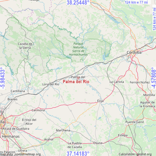
Palma del Río GPS coordinates[2]
37° 42' 0.864" North, 5° 16' 52.356" West
| Map corner | latitude | longitude |
|---|---|---|
| Upper-left | 38.25448°, | -5.98433° |
| Center: | 37.70024°, | -5.28121° |
| Lower-right: | 37.14183°, | -4.57808° |
| Map W x H: | 123.7×123.7 km | = 76.9×76.9mi |
| max Lat: | 43.74134° ⇑90.1% North |
| Palma del Río: | 37.70024° |
| min Lat: | ⇓9.9% South 27.64134° |
| min Long | Palma del Río | max Long |
| -18.00367° | -5.28121° | 4.2899° |
| W 23.9%⇐ | ⇒76.1% E |
Elevation
Elevation of Palma del Río is 60 m = 197 ft, and this is 538 m = 1765 ft below average elevation for this country.
| Max E: |
1682 m = 5518 ft | 90.4% |
| Avg. | 598 m = 1962 ft | |
| Palma del Río | 60 m = 197 ft | |
Min E: |
0 m = 0 ft | 9.6% |
See also: Spain elevation on elevation.city.
Geographical zone
Palma del Río is located in North temperate zone (between Tropic of Cancer and the Arctic Circle). Distance of this Northern Tropic circle is 1586 km =985.5 mi to South.| Distance of | km | miles | from Palma del Río |
|---|---|---|---|
| North Pole | 5815.2 | 3613.4 | to North |
| Arctic Circle | 3209.3 | 1994.2 | to North |
| Tropic Cancer | 1586 | 985.5 | to South |
| Equator | 4191.9 | 2604.7 | to South |


Nearby cities:
15 places around Palma del Río: (largest is in red/bold)
• Almodóvar del Río
26 km =16.2 mi,  61°
61°
• Cañada Rosal
12.9 km =8 mi,  150°
150°
• Constantina
34.8 km =21.6 mi,  302°
302°
• Fuente Palmera
16 km =9.9 mi,  88°
88°
• Fuentes de Andalucía
26.9 km =16.7 mi,  192°
192°
• Guadalcázar
30.3 km =18.8 mi,  77°
77°
• Hornachuelos
15.4 km =9.6 mi,  15°
15°
• La Campana
19.4 km =12.1 mi,  221°
221°
• La Carlota
30.9 km =19.2 mi,  95°
95°
• La Luisiana
19.6 km =12.2 mi,  171°
171°
• La Puebla de los Infantes
13 km =8.1 mi,  313°
313°
• Lora del Río
22.2 km =13.8 mi,  258°
258°
• Peñaflor
5.7 km =3.5 mi,  279°
279°
• Posadas
19 km =11.8 mi,  53°
53°
• Écija
24.8 km =15.4 mi,  135°
135°
Sources, notices
• [Note1] Compared only with cities in Spain existing in our database
• [Src1] Map data: © OpenStreetMap contributors (CC-BY-SA)
• [Src2] Other city data from geonames.org with taken over terms of usage.
• [Src3] Geographical zone / Annual Mean Temperature by Robert A. Rohde @ Wikipedia
