Peñaflor geodata
Peñaflor (Andalusia) is a seat of a third-order administrative division; located in Spain in Europe/Madrid (GMT+2) time zone. With population of 3,688 people, there are 1541 cities with bigger population in this country. Compared to other cities in Spain, 90.1% of cities are located further ↑North; 76.8% of cities are located further →East and 89.9% of cities have higher elevation than Peñaflor. Note1


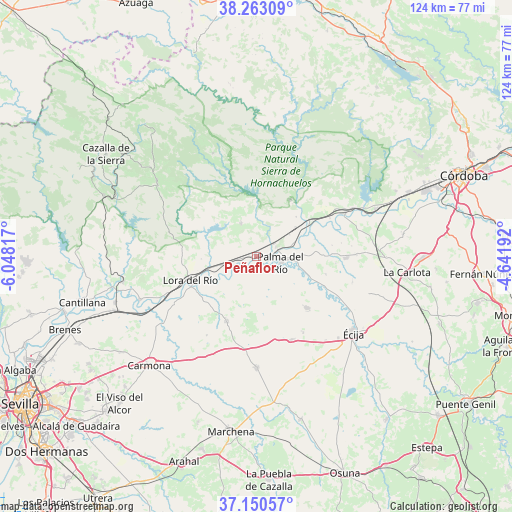
Peñaflor GPS coordinates[2]
37° 42' 32.112" North, 5° 20' 42.144" West
| Map corner | latitude | longitude |
|---|---|---|
| Upper-left | 38.26309°, | -6.04817° |
| Center: | 37.70892°, | -5.34504° |
| Lower-right: | 37.15057°, | -4.64192° |
| Map W x H: | 123.7×123.7 km | = 76.9×76.9mi |
| max Lat: | 43.74134° ⇑90.1% North |
| Peñaflor: | 37.70892° |
| min Lat: | ⇓9.9% South 27.64134° |
| min Long | Peñaflor | max Long |
| -18.00367° | -5.34504° | 4.2899° |
| W 23.2%⇐ | ⇒76.8% E |
Elevation
Elevation of Peñaflor is 68 m = 223 ft, and this is 530 m = 1739 ft below average elevation for this country.
| Max E: |
1682 m = 5518 ft | 89.9% |
| Avg. | 598 m = 1962 ft | |
| Peñaflor | 68 m = 223 ft | |
Min E: |
0 m = 0 ft | 10.1% |
See also: Spain elevation on elevation.city.
Geographical zone
Peñaflor is located in North temperate zone (between Tropic of Cancer and the Arctic Circle). Distance of this Northern Tropic circle is 1586.9 km =986.1 mi to South.| Distance of | km | miles | from Peñaflor |
|---|---|---|---|
| North Pole | 5814.2 | 3612.8 | to North |
| Arctic Circle | 3208.3 | 1993.5 | to North |
| Tropic Cancer | 1586.9 | 986.1 | to South |
| Equator | 4192.8 | 2605.3 | to South |


Nearby cities:
15 places around Peñaflor: (largest is in red/bold)
• Alcolea del Río
30.2 km =18.8 mi,  249°
249°
• Almodóvar del Río
30.7 km =19.1 mi,  68°
68°
• Cañada Rosal
17 km =10.6 mi,  135°
135°
• Constantina
29.6 km =18.4 mi,  306°
306°
• Fuente Palmera
21.6 km =13.4 mi,  91°
91°
• Fuentes de Andalucía
27.2 km =16.9 mi,  180°
180°
• Hornachuelos
17 km =10.6 mi,  35°
35°
• La Campana
17.1 km =10.6 mi,  204°
204°
• La Luisiana
22 km =13.7 mi,  157°
157°
• La Puebla de los Infantes
8.9 km =5.5 mi,  334°
334°
• Lora del Río
17 km =10.6 mi, 250°
• Palma del Río
5.7 km =3.5 mi,  99°
99°
• Posadas
23.3 km =14.5 mi,  63°
63°
• Villanueva del Río y Minas
33 km =20.5 mi,  259°
259°
• Écija
29.6 km =18.4 mi,  128°
128°
Sources, notices
• [Note1] Compared only with cities in Spain existing in our database
• [Src1] Map data: © OpenStreetMap contributors (CC-BY-SA)
• [Src2] Other city data from geonames.org with taken over terms of usage.
• [Src3] Geographical zone / Annual Mean Temperature by Robert A. Rohde @ Wikipedia
