Catral geodata
Catral (Valencia) is a seat of a third-order administrative division; located in Spain in Europe/Madrid (GMT+2) time zone. With population of 6,147 people, there are 1118 cities with bigger population in this country. Compared to other cities in Spain, 87.4% of cities are located further ↑North; 78.8% of cities are located further ←West and 98.2% of cities have higher elevation than Catral. Note1


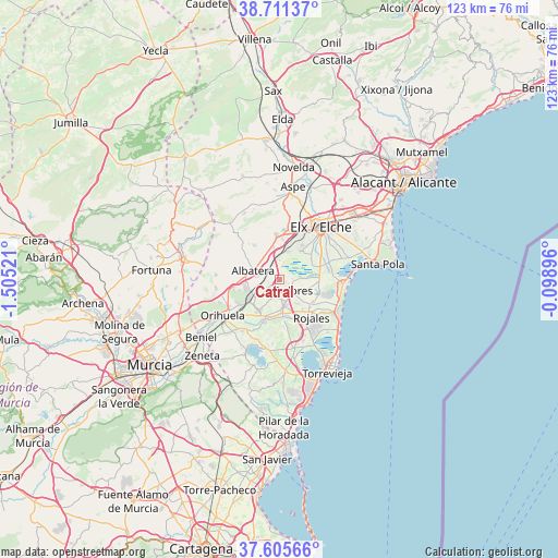
Catral GPS coordinates[2]
38° 9' 38.196" North, 0° 48' 7.524" West
| Map corner | latitude | longitude |
|---|---|---|
| Upper-left | 38.71137°, | -1.50521° |
| Center: | 38.16061°, | -0.80209° |
| Lower-right: | 37.60566°, | -0.09896° |
| Map W x H: | 122.9×122.9 km | = 76.4×76.4mi |
| max Lat: | 43.74134° ⇑87.4% North |
| Catral: | 38.16061° |
| min Lat: | ⇓12.6% South 27.64134° |
| min Long | Catral | max Long |
| -18.00367° | -0.80209° | 4.2899° |
| W 78.8%⇐ | ⇒21.2% E |
Elevation
Elevation of Catral is 11 m = 36 ft, and this is 587 m = 1926 ft below average elevation for this country.
| Max E: |
1682 m = 5518 ft | 98.2% |
| Avg. | 598 m = 1962 ft | |
| Catral | 11 m = 36 ft | |
Min E: |
0 m = 0 ft | 1.8% |
See also: Spain elevation on elevation.city.
Geographical zone
Catral is located in North temperate zone (between Tropic of Cancer and the Arctic Circle). Distance of this Northern Tropic circle is 1637.1 km =1017.2 mi to South.| Distance of | km | miles | from Catral |
|---|---|---|---|
| North Pole | 5764 | 3581.6 | to North |
| Arctic Circle | 3158.1 | 1962.4 | to North |
| Tropic Cancer | 1637.1 | 1017.2 | to South |
| Equator | 4243.1 | 2636.5 | to South |


Nearby cities:
15 places around Catral: (largest is in red/bold)
• Albatera
6.3 km =3.9 mi,  288°
288°
• Algorfa
8.3 km =5.2 mi,  176°
176°
• Almoradí
5.8 km =3.6 mi,  171°
171°
• Benejúzar
9.8 km =6.1 mi,  199°
199°
• Callosa de Segura
7.7 km =4.8 mi,  239°
239°
• Cox
7.7 km =4.8 mi,  254°
254°
• Crevillente
10 km =6.2 mi,  356°
356°
• Daya Nueva
6.4 km =4 mi,  145°
145°
• Daya Vieja
8.4 km =5.2 mi,  137°
137°
• Dolores
3.6 km =2.2 mi,  129°
129°
• Formentera de Segura
9.7 km =6 mi, 149°
• Granja de Rocamora
7.9 km =4.9 mi,  262°
262°
• Rafal
7.5 km =4.7 mi,  213°
213°
• Rojales
10.5 km =6.5 mi, 140°
• San Isidro
3.5 km =2.2 mi, 292°
Sources, notices
• [Note1] Compared only with cities in Spain existing in our database
• [Src1] Map data: © OpenStreetMap contributors (CC-BY-SA)
• [Src2] Other city data from geonames.org with taken over terms of usage.
• [Src3] Geographical zone / Annual Mean Temperature by Robert A. Rohde @ Wikipedia
