Dolores geodata
Dolores (Valencia) is a seat of a third-order administrative division; located in Spain in Europe/Madrid (GMT+2) time zone. With population of 7,132 people, there are 1021 cities with bigger population in this country. Compared to other cities in Spain, 87.6% of cities are located further ↑North; 79.1% of cities are located further ←West and 98.7% of cities have higher elevation than Dolores. Note1


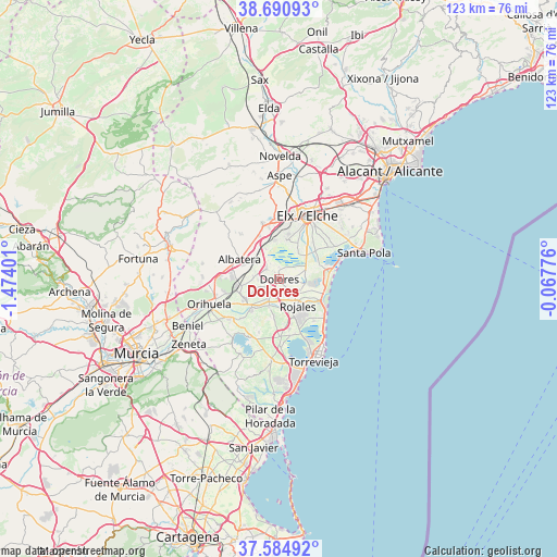
Dolores GPS coordinates[2]
38° 8' 24.072" North, 0° 46' 15.168" West
| Map corner | latitude | longitude |
|---|---|---|
| Upper-left | 38.69093°, | -1.47401° |
| Center: | 38.14002°, | -0.77088° |
| Lower-right: | 37.58492°, | -0.06776° |
| Map W x H: | 123×123 km | = 76.4×76.4mi |
| max Lat: | 43.74134° ⇑87.6% North |
| Dolores: | 38.14002° |
| min Lat: | ⇓12.4% South 27.64134° |
| min Long | Dolores | max Long |
| -18.00367° | -0.77088° | 4.2899° |
| W 79.1%⇐ | ⇒20.9% E |
Elevation
Elevation of Dolores is 9 m = 30 ft, and this is 589 m = 1932 ft below average elevation for this country.
| Max E: |
1682 m = 5518 ft | 98.7% |
| Avg. | 598 m = 1962 ft | |
| Dolores | 9 m = 30 ft | |
Min E: |
0 m = 0 ft | 1.3% |
See also: Spain elevation on elevation.city.
Geographical zone
Dolores is located in North temperate zone (between Tropic of Cancer and the Arctic Circle). Distance of this Northern Tropic circle is 1634.9 km =1015.9 mi to South.| Distance of | km | miles | from Dolores |
|---|---|---|---|
| North Pole | 5766.3 | 3583 | to North |
| Arctic Circle | 3160.4 | 1963.8 | to North |
| Tropic Cancer | 1634.9 | 1015.9 | to South |
| Equator | 4240.8 | 2635.1 | to South |


Nearby cities:
15 places around Dolores: (largest is in red/bold)
• Albatera
9.7 km =6 mi,  296°
296°
• Algorfa
6.4 km =4 mi,  200°
200°
• Almoradí
3.9 km =2.4 mi,  207°
207°
• Benejúzar
9.2 km =5.7 mi,  220°
220°
• Benijofar
7.5 km =4.7 mi,  156°
156°
• Callosa de Segura
9.5 km =5.9 mi,  259°
259°
• Catral
3.6 km =2.2 mi,  309°
309°
• Cox
10.2 km =6.3 mi,  271°
271°
• Daya Nueva
3.1 km =1.9 mi, 162°
• Daya Vieja
4.9 km =3 mi,  143°
143°
• Formentera de Segura
6.5 km =4 mi, 160°
• Granja de Rocamora
10.6 km =6.6 mi,  276°
276°
• Rafal
7.9 km =4.9 mi,  240°
240°
• Rojales
7 km =4.3 mi,  145°
145°
• San Isidro
6.9 km =4.3 mi, 301°
Sources, notices
• [Note1] Compared only with cities in Spain existing in our database
• [Src1] Map data: © OpenStreetMap contributors (CC-BY-SA)
• [Src2] Other city data from geonames.org with taken over terms of usage.
• [Src3] Geographical zone / Annual Mean Temperature by Robert A. Rohde @ Wikipedia
