Albatera geodata
Albatera (Valencia) is a seat of a third-order administrative division; located in Spain in Europe/Madrid (GMT+2) time zone. With population of 11,745 people, there are 757 cities with bigger population in this country. Compared to other cities in Spain, 87.3% of cities are located further ↑North; 78.2% of cities are located further ←West and 95.8% of cities have higher elevation than Albatera. Note1


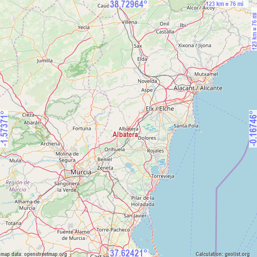
Albatera GPS coordinates[2]
38° 10' 44.472" North, 0° 52' 14.124" West
| Map corner | latitude | longitude |
|---|---|---|
| Upper-left | 38.72964°, | -1.57371° |
| Center: | 38.17902°, | -0.87059° |
| Lower-right: | 37.62421°, | -0.16746° |
| Map W x H: | 122.9×122.9 km | = 76.4×76.4mi |
| max Lat: | 43.74134° ⇑87.3% North |
| Albatera: | 38.17902° |
| min Lat: | ⇓12.7% South 27.64134° |
| min Long | Albatera | max Long |
| -18.00367° | -0.87059° | 4.2899° |
| W 78.2%⇐ | ⇒21.8% E |
Elevation
Elevation of Albatera is 21 m = 69 ft, and this is 577 m = 1893 ft below average elevation for this country.
| Max E: |
1682 m = 5518 ft | 95.8% |
| Avg. | 598 m = 1962 ft | |
| Albatera | 21 m = 69 ft | |
Min E: |
0 m = 0 ft | 4.2% |
See also: Spain elevation on elevation.city.
Geographical zone
Albatera is located in North temperate zone (between Tropic of Cancer and the Arctic Circle). Distance of this Northern Tropic circle is 1639.2 km =1018.6 mi to South.| Distance of | km | miles | from Albatera |
|---|---|---|---|
| North Pole | 5762 | 3580.3 | to North |
| Arctic Circle | 3156.1 | 1961.1 | to North |
| Tropic Cancer | 1639.2 | 1018.6 | to South |
| Equator | 4245.1 | 2637.8 | to South |


Nearby cities:
15 places around Albatera: (largest is in red/bold)
• Algorfa
12.2 km =7.6 mi,  147°
147°
• Almoradí
10.4 km =6.5 mi,  138°
138°
• Benejúzar
11.6 km =7.2 mi,  166°
166°
• Benferri
9 km =5.6 mi,  242°
242°
• Callosa de Segura
6 km =3.7 mi,  186°
186°
• Catral
6.3 km =3.9 mi,  108°
108°
• Cox
4.4 km =2.7 mi,  199°
199°
• Crevillente
9.5 km =5.9 mi,  33°
33°
• Daya Nueva
12.1 km =7.5 mi,  127°
127°
• Dolores
9.7 km =6 mi,  116°
116°
• Granja de Rocamora
3.6 km =2.2 mi,  211°
211°
• Hondón de los Frailes
11.7 km =7.3 mi,  334°
334°
• Rafal
8.5 km =5.3 mi, 167°
• Redován
7.8 km =4.8 mi, 206°
• San Isidro
2.9 km =1.8 mi,  104°
104°
Sources, notices
• [Note1] Compared only with cities in Spain existing in our database
• [Src1] Map data: © OpenStreetMap contributors (CC-BY-SA)
• [Src2] Other city data from geonames.org with taken over terms of usage.
• [Src3] Geographical zone / Annual Mean Temperature by Robert A. Rohde @ Wikipedia
