Carriches geodata
Carriches (Castille-La Mancha) is a seat of a third-order administrative division; located in Spain in Europe/Madrid (GMT+2) time zone. With population of 312 people, there are 4455 cities with bigger population in this country. Compared to other cities in Spain, 70.8% of cities are located further ↑North; 65.6% of cities are located further →East and 58.1% of cities have higher elevation than Carriches. Note1
Administrative division(s):
- Level 1: Castille-La Mancha
- Level 2: Province of Toledo
- Level 3: Carriches


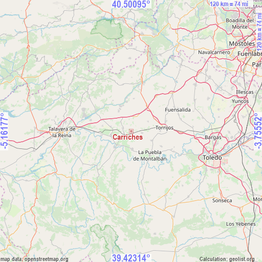
Carriches GPS coordinates[2]
39° 57' 51.012" North, 4° 27' 31.104" West
| Map corner | latitude | longitude |
|---|---|---|
| Upper-left | 40.50095°, | -5.16177° |
| Center: | 39.96417°, | -4.45864° |
| Lower-right: | 39.42314°, | -3.75552° |
| Map W x H: | 119.8×119.8 km | = 74.4×74.4mi |
| max Lat: | 43.74134° ⇑70.8% North |
| Carriches: | 39.96417° |
| min Lat: | ⇓29.2% South 27.64134° |
| min Long | Carriches | max Long |
| -18.00367° | -4.45864° | 4.2899° |
| W 34.4%⇐ | ⇒65.6% E |
Elevation
Elevation of Carriches is 551 m = 1808 ft, and this is 47 m = 154 ft below average elevation for this country.
| Max E: |
1682 m = 5518 ft | 58.1% |
| Avg. | 598 m = 1962 ft | |
| Carriches | 551 m = 1808 ft | |
Min E: |
0 m = 0 ft | 41.9% |
See also: Spain elevation on elevation.city.
Geographical zone
Carriches is located in North temperate zone (between Tropic of Cancer and the Arctic Circle). Distance of this Northern Tropic circle is 1837.7 km =1141.9 mi to South.| Distance of | km | miles | from Carriches |
|---|---|---|---|
| North Pole | 5563.5 | 3457 | to North |
| Arctic Circle | 2957.6 | 1837.8 | to North |
| Tropic Cancer | 1837.7 | 1141.9 | to South |
| Equator | 4443.6 | 2761.1 | to South |


Nearby cities:
15 places around Carriches: (largest is in red/bold)
• Alcabón
8.8 km =5.5 mi,  61°
61°
• Carmena
5 km =3.1 mi,  101°
101°
• Cebolla
9.8 km =6.1 mi,  260°
260°
• Domingo Pérez
4.2 km =2.6 mi,  289°
289°
• El Carpio de Tajo
8.5 km =5.3 mi,  177°
177°
• El Casar de Escalona
10.8 km =6.7 mi,  328°
328°
• Erustes
3.3 km =2.1 mi, 255°
• Escalonilla
10.1 km =6.3 mi,  114°
114°
• Gerindote
13.3 km =8.3 mi,  89°
89°
• Illán de Vacas
8.5 km =5.3 mi,  274°
274°
• La Mata
3.1 km =1.9 mi,  145°
145°
• Lucillos
13.3 km =8.3 mi,  280°
280°
• Malpica
10.7 km =6.6 mi,  226°
226°
• Otero
6.3 km =3.9 mi,  310°
310°
• Santa Olalla
7 km =4.3 mi,  20°
20°
Sources, notices
• [Note1] Compared only with cities in Spain existing in our database
• [Src1] Map data: © OpenStreetMap contributors (CC-BY-SA)
• [Src2] Other city data from geonames.org with taken over terms of usage.
• [Src3] Geographical zone / Annual Mean Temperature by Robert A. Rohde @ Wikipedia
