Santa Olalla geodata
Santa Olalla (Castille-La Mancha) is a seat of a third-order administrative division; located in Spain in Europe/Madrid (GMT+2) time zone. With population of 3,024 people, there are 1712 cities with bigger population in this country. Compared to other cities in Spain, 69.9% of cities are located further ↑North; 65.3% of cities are located further →East and 63.1% of cities have higher elevation than Santa Olalla. Note1
Administrative division(s):
- Level 1: Castille-La Mancha
- Level 2: Province of Toledo
- Level 3: Santa Olalla


Santa Olalla GPS coordinates[2]
40° 1' 24.528" North, 4° 25' 48.9" West
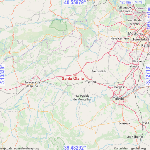
| Map corner | latitude | longitude |
|---|---|---|
| Upper-left | 40.55979°, | -5.13338° |
| Center: | 40.02348°, | -4.43025° |
| Lower-right: | 39.48292°, | -3.72713° |
| Map W x H: | 119.7×119.7 km | = 74.4×74.4mi |
| max Lat: | 43.74134° ⇑69.9% North |
| Santa Olalla: | 40.02348° |
| min Lat: | ⇓30.1% South 27.64134° |
| min Long | Santa Olalla | max Long |
| -18.00367° | -4.43025° | 4.2899° |
| W 34.7%⇐ | ⇒65.3% E |
Elevation
Elevation of Santa Olalla is 486 m = 1594 ft, and this is 112 m = 367 ft below average elevation for this country.
| Max E: |
1682 m = 5518 ft | 63.1% |
| Avg. | 598 m = 1962 ft | |
| Santa Olalla | 486 m = 1594 ft | |
Min E: |
0 m = 0 ft | 36.9% |
See also: Spain elevation on elevation.city.
Geographical zone
Santa Olalla is located in North temperate zone (between Tropic of Cancer and the Arctic Circle). Distance of this Northern Tropic circle is 1844.3 km =1146 mi to South.| Distance of | km | miles | from Santa Olalla |
|---|---|---|---|
| North Pole | 5556.9 | 3452.9 | to North |
| Arctic Circle | 2951 | 1833.7 | to North |
| Tropic Cancer | 1844.3 | 1146 | to South |
| Equator | 4450.2 | 2765.2 | to South |


Nearby cities:
15 places around Santa Olalla: (largest is in red/bold)
• Alcabón
5.8 km =3.6 mi,  114°
114°
• Carmena
7.9 km =4.9 mi,  162°
162°
• Carriches
7 km =4.3 mi,  200°
200°
• Domingo Pérez
8.3 km =5.2 mi,  230°
230°
• El Casar de Escalona
8.5 km =5.3 mi,  287°
287°
• Erustes
9.3 km =5.8 mi,  217°
217°
• Escalonilla
12.8 km =8 mi,  148°
148°
• Gerindote
12.6 km =7.8 mi,  120°
120°
• Hormigos
8.4 km =5.2 mi,  351°
351°
• Illán de Vacas
12.3 km =7.6 mi,  241°
241°
• La Mata
9.2 km =5.7 mi,  184°
184°
• Maqueda
6.9 km =4.3 mi,  46°
46°
• Otero
7.7 km =4.8 mi,  250°
250°
• Quismondo
12.8 km =8 mi,  44°
44°
• Torrijos
13.3 km =8.3 mi, 110°
Sources, notices
• [Note1] Compared only with cities in Spain existing in our database
• [Src1] Map data: © OpenStreetMap contributors (CC-BY-SA)
• [Src2] Other city data from geonames.org with taken over terms of usage.
• [Src3] Geographical zone / Annual Mean Temperature by Robert A. Rohde @ Wikipedia
