Guadamur geodata
Guadamur (Castille-La Mancha) is a seat of a third-order administrative division; located in Spain in Europe/Madrid (GMT+2) time zone. With population of 1,737 people, there are 2318 cities with bigger population in this country. Compared to other cities in Spain, 72.8% of cities are located further ↑North; 61.9% of cities are located further →East and 52.6% of cities have higher elevation than Guadamur. Note1
Administrative division(s):
- Level 1: Castille-La Mancha
- Level 2: Province of Toledo
- Level 3: Guadamur


Guadamur GPS coordinates[2]
39° 48' 42.408" North, 4° 8' 55.86" West
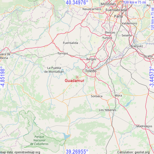
| Map corner | latitude | longitude |
|---|---|---|
| Upper-left | 40.34976°, | -4.85198° |
| Center: | 39.81178°, | -4.14885° |
| Lower-right: | 39.26955°, | -3.44573° |
| Map W x H: | 120.1×120.1 km | = 74.6×74.6mi |
| max Lat: | 43.74134° ⇑72.8% North |
| Guadamur: | 39.81178° |
| min Lat: | ⇓27.2% South 27.64134° |
| min Long | Guadamur | max Long |
| -18.00367° | -4.14885° | 4.2899° |
| W 38.1%⇐ | ⇒61.9% E |
Elevation
Elevation of Guadamur is 629 m = 2064 ft, and this is 31 m = 102 ft above average elevation for this country.
| Max E: |
1682 m = 5518 ft | 52.6% |
| Guadamur | 629 m 2064 ft | |
| Avg. | 598 m = 1962 ft | |
Min E: |
0 m = 0 ft | 47.4% |
See also: Spain elevation on elevation.city.
Geographical zone
Guadamur is located in North temperate zone (between Tropic of Cancer and the Arctic Circle). Distance of this Northern Tropic circle is 1820.7 km =1131.3 mi to South.| Distance of | km | miles | from Guadamur |
|---|---|---|---|
| North Pole | 5580.4 | 3467.5 | to North |
| Arctic Circle | 2974.5 | 1848.3 | to North |
| Tropic Cancer | 1820.7 | 1131.3 | to South |
| Equator | 4426.7 | 2750.6 | to South |


Nearby cities:
15 places around Guadamur: (largest is in red/bold)
• Albarreal de Tajo
11.7 km =7.3 mi,  324°
324°
• Burguillos de Toledo
13.5 km =8.4 mi,  97°
97°
• Burujón
16.1 km =10 mi,  308°
308°
• Casasbuenas
6 km =3.7 mi,  160°
160°
• Cobisa
10.6 km =6.6 mi,  94°
94°
• Gálvez
16.1 km =10 mi,  220°
220°
• Layos
8.2 km =5.1 mi,  118°
118°
• Mazarambroz
17.1 km =10.6 mi,  139°
139°
• Noez
8.4 km =5.2 mi,  200°
200°
• Polán
3.1 km =1.9 mi,  211°
211°
• Pulgar
13.1 km =8.1 mi,  181°
181°
• Rielves
17.1 km =10.6 mi,  347°
347°
• Toledo
11.9 km =7.4 mi,  64°
64°
• Totanés
13.1 km =8.1 mi, 210°
• Villamiel de Toledo
17.1 km =10.6 mi,  6°
6°
Sources, notices
• [Note1] Compared only with cities in Spain existing in our database
• [Src1] Map data: © OpenStreetMap contributors (CC-BY-SA)
• [Src2] Other city data from geonames.org with taken over terms of usage.
• [Src3] Geographical zone / Annual Mean Temperature by Robert A. Rohde @ Wikipedia
