Beniardá geodata
Beniardá (Valencia) is a seat of a third-order administrative division; located in Spain in Europe/Madrid (GMT+2) time zone. With population of 186 people, there are 5137 cities with bigger population in this country. Compared to other cities in Spain, 84.4% of cities are located further ↑North; 85.4% of cities are located further ←West and 64.3% of cities have higher elevation than Beniardá. Note1


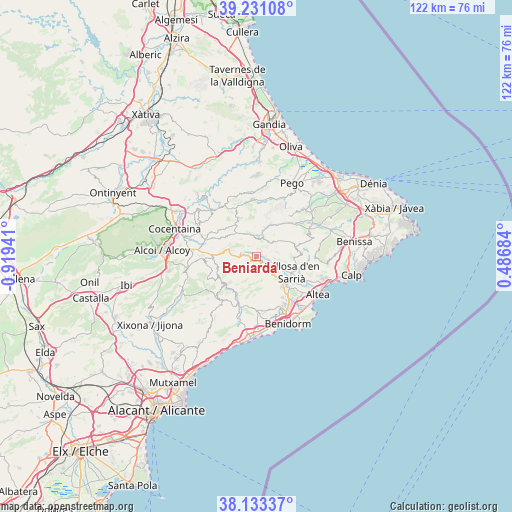
Beniardá GPS coordinates[2]
38° 41' 3.588" North, 0° 12' 58.644" West
| Map corner | latitude | longitude |
|---|---|---|
| Upper-left | 39.23108°, | -0.91941° |
| Center: | 38.68433°, | -0.21629° |
| Lower-right: | 38.13337°, | 0.48684° |
| Map W x H: | 122.1×122.1 km | = 75.9×75.9mi |
| max Lat: | 43.74134° ⇑84.4% North |
| Beniardá: | 38.68433° |
| min Lat: | ⇓15.6% South 27.64134° |
| min Long | Beniardá | max Long |
| -18.00367° | -0.21629° | 4.2899° |
| W 85.4%⇐ | ⇒14.6% E |
Elevation
Elevation of Beniardá is 468 m = 1535 ft, and this is 130 m = 427 ft below average elevation for this country.
| Max E: |
1682 m = 5518 ft | 64.3% |
| Avg. | 598 m = 1962 ft | |
| Beniardá | 468 m = 1535 ft | |
Min E: |
0 m = 0 ft | 35.7% |
See also: Spain elevation on elevation.city.
Geographical zone
Beniardá is located in North temperate zone (between Tropic of Cancer and the Arctic Circle). Distance of this Northern Tropic circle is 1695.4 km =1053.5 mi to South.| Distance of | km | miles | from Beniardá |
|---|---|---|---|
| North Pole | 5705.8 | 3545.4 | to North |
| Arctic Circle | 3099.9 | 1926.2 | to North |
| Tropic Cancer | 1695.4 | 1053.5 | to South |
| Equator | 4301.3 | 2672.7 | to South |


Nearby cities:
15 places around Beniardá: (largest is in red/bold)
• Benasau
11 km =6.8 mi,  273°
273°
• Benichembla
12.2 km =7.6 mi,  49°
49°
• Benimantell
0.9 km =0.6 mi,  148°
148°
• Benimassot
9.3 km =5.8 mi,  321°
321°
• Bolulla
9.1 km =5.7 mi,  96°
96°
• Callosa d'En Sarrià
9.5 km =5.9 mi,  113°
113°
• Castell de Castells
5 km =3.1 mi,  24°
24°
• Confrides
4.6 km =2.9 mi, 270°
• Facheca
7.2 km =4.5 mi, 321°
• Famorca
5.8 km =3.6 mi,  332°
332°
• Polop
10.1 km =6.3 mi,  132°
132°
• Sella
9.7 km =6 mi,  210°
210°
• Tollos
9.5 km =5.9 mi, 327°
• Tárbena
10 km =6.2 mi,  83°
83°
• la Nucia
11 km =6.8 mi,  135°
135°
Sources, notices
• [Note1] Compared only with cities in Spain existing in our database
• [Src1] Map data: © OpenStreetMap contributors (CC-BY-SA)
• [Src2] Other city data from geonames.org with taken over terms of usage.
• [Src3] Geographical zone / Annual Mean Temperature by Robert A. Rohde @ Wikipedia
