Bolulla geodata
Bolulla (Valencia) is a seat of a third-order administrative division; located in Spain in Europe/Madrid (GMT+2) time zone. With population of 355 people, there are 4297 cities with bigger population in this country. Compared to other cities in Spain, 84.5% of cities are located further ↑North; 86.3% of cities are located further ←West and 79.2% of cities have higher elevation than Bolulla. Note1


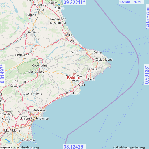
Bolulla GPS coordinates[2]
38° 40' 31.044" North, 0° 6' 42.624" West
| Map corner | latitude | longitude |
|---|---|---|
| Upper-left | 39.22211°, | -0.81497° |
| Center: | 38.67529°, | -0.11184° |
| Lower-right: | 38.12426°, | 0.59128° |
| Map W x H: | 122.1×122.1 km | = 75.9×75.9mi |
| max Lat: | 43.74134° ⇑84.5% North |
| Bolulla: | 38.67529° |
| min Lat: | ⇓15.5% South 27.64134° |
| min Long | Bolulla | max Long |
| -18.00367° | -0.11184° | 4.2899° |
| W 86.3%⇐ | ⇒13.7% E |
Elevation
Elevation of Bolulla is 235 m = 771 ft, and this is 363 m = 1191 ft below average elevation for this country.
| Max E: |
1682 m = 5518 ft | 79.2% |
| Avg. | 598 m = 1962 ft | |
| Bolulla | 235 m = 771 ft | |
Min E: |
0 m = 0 ft | 20.8% |
See also: Spain elevation on elevation.city.
Geographical zone
Bolulla is located in North temperate zone (between Tropic of Cancer and the Arctic Circle). Distance of this Northern Tropic circle is 1694.4 km =1052.9 mi to South.| Distance of | km | miles | from Bolulla |
|---|---|---|---|
| North Pole | 5706.8 | 3546 | to North |
| Arctic Circle | 3100.9 | 1926.8 | to North |
| Tropic Cancer | 1694.4 | 1052.9 | to South |
| Equator | 4300.3 | 2672.1 | to South |


Nearby cities:
15 places around Bolulla: (largest is in red/bold)
• Alcalalí
10.4 km =6.5 mi,  36°
36°
• Altea
10 km =6.2 mi,  148°
148°
• Beniardá
9.1 km =5.7 mi,  276°
276°
• Benichembla
8.9 km =5.5 mi,  1°
1°
• Benimantell
8.6 km =5.3 mi,  271°
271°
• Callosa d'En Sarrià
2.8 km =1.7 mi,  188°
188°
• Castell de Castells
9 km =5.6 mi,  308°
308°
• Jalón
11.4 km =7.1 mi,  50°
50°
• Murla
9.8 km =6.1 mi,  15°
15°
• Orba
12.4 km =7.7 mi, 20°
• Parcent
8.8 km =5.5 mi,  27°
27°
• Polop
6.1 km =3.8 mi,  195°
195°
• Tárbena
2.3 km =1.4 mi, 23°
• l'Alfàs del Pi
10.6 km =6.6 mi,  175°
175°
• la Nucia
7 km =4.3 mi, 190°
Sources, notices
• [Note1] Compared only with cities in Spain existing in our database
• [Src1] Map data: © OpenStreetMap contributors (CC-BY-SA)
• [Src2] Other city data from geonames.org with taken over terms of usage.
• [Src3] Geographical zone / Annual Mean Temperature by Robert A. Rohde @ Wikipedia
