la Nucia geodata
la Nucia (Valencia) is a populated place; located in Spain in Europe/Madrid (GMT+2) time zone. With population of 17,874 people, there are 526 cities with bigger population in this country. Compared to other cities in Spain, 84.9% of cities are located further ↑North; 86.3% of cities are located further ←West and 78.9% of cities have higher elevation than la Nucia. Note1


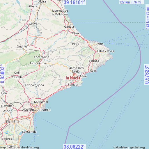
la Nucia GPS coordinates[2]
38° 36' 49.392" North, 0° 7' 36.84" West
| Map corner | latitude | longitude |
|---|---|---|
| Upper-left | 39.16101°, | -0.83003° |
| Center: | 38.61372°, | -0.1269° |
| Lower-right: | 38.06222°, | 0.57623° |
| Map W x H: | 122.2×122.2 km | = 75.9×75.9mi |
| max Lat: | 43.74134° ⇑84.9% North |
| la Nucia: | 38.61372° |
| min Lat: | ⇓15.1% South 27.64134° |
| min Long | la Nucia | max Long |
| -18.00367° | -0.1269° | 4.2899° |
| W 86.3%⇐ | ⇒13.7% E |
Elevation
Elevation of la Nucia is 240 m = 787 ft, and this is 358 m = 1175 ft below average elevation for this country.
| Max E: |
1682 m = 5518 ft | 78.9% |
| Avg. | 598 m = 1962 ft | |
| la Nucia | 240 m = 787 ft | |
Min E: |
0 m = 0 ft | 21.1% |
See also: Spain elevation on elevation.city.
Geographical zone
la Nucia is located in North temperate zone (between Tropic of Cancer and the Arctic Circle). Distance of this Northern Tropic circle is 1687.5 km =1048.6 mi to South.| Distance of | km | miles | from la Nucia |
|---|---|---|---|
| North Pole | 5713.6 | 3550.3 | to North |
| Arctic Circle | 3107.7 | 1931 | to North |
| Tropic Cancer | 1687.5 | 1048.6 | to South |
| Equator | 4293.4 | 2667.8 | to South |


Nearby cities:
15 places around la Nucia: (largest is in red/bold)
• Altea
6.8 km =4.2 mi,  104°
104°
• Beniardá
11 km =6.8 mi,  315°
315°
• Benidorm
8.4 km =5.2 mi,  182°
182°
• Benimantell
10.1 km =6.3 mi,  314°
314°
• Bolulla
7 km =4.3 mi,  10°
10°
• Callosa d'En Sarrià
4.1 km =2.5 mi, 12°
• Castell de Castells
13.7 km =8.5 mi,  335°
335°
• Confrides
14.6 km =9.1 mi,  302°
302°
• Finestrat
9 km =5.6 mi,  235°
235°
• Orcheta
13.1 km =8.1 mi, 244°
• Polop
1 km =0.6 mi, 340°
• Sella
12.7 km =7.9 mi,  267°
267°
• Tárbena
9.2 km =5.7 mi, 13°
• Villajoyosa
15 km =9.3 mi,  218°
218°
• l'Alfàs del Pi
4.2 km =2.6 mi,  150°
150°
Sources, notices
• [Note1] Compared only with cities in Spain existing in our database
• [Src1] Map data: © OpenStreetMap contributors (CC-BY-SA)
• [Src2] Other city data from geonames.org with taken over terms of usage.
• [Src3] Geographical zone / Annual Mean Temperature by Robert A. Rohde @ Wikipedia
