Polop geodata
Polop (Valencia) is a populated place; located in Spain in Europe/Madrid (GMT+2) time zone. With population of 3,354 people, there are 1621 cities with bigger population in this country. Compared to other cities in Spain, 84.8% of cities are located further ↑North; 86.2% of cities are located further ←West and 80.2% of cities have higher elevation than Polop. Note1
Administrative division(s):
- Level 1: Valencia
- Level 2: Provincia de Alicante
- Level 3: Polop de Marina


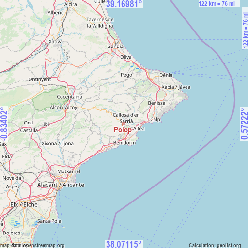
Polop GPS coordinates[2]
38° 37' 21.288" North, 0° 7' 51.24" West
| Map corner | latitude | longitude |
|---|---|---|
| Upper-left | 39.16981°, | -0.83402° |
| Center: | 38.62258°, | -0.1309° |
| Lower-right: | 38.07115°, | 0.57222° |
| Map W x H: | 122.2×122.2 km | = 75.9×75.9mi |
| max Lat: | 43.74134° ⇑84.8% North |
| Polop: | 38.62258° |
| min Lat: | ⇓15.2% South 27.64134° |
| min Long | Polop | max Long |
| -18.00367° | -0.1309° | 4.2899° |
| W 86.2%⇐ | ⇒13.8% E |
Elevation
Elevation of Polop is 217 m = 712 ft, and this is 381 m = 1250 ft below average elevation for this country.
| Max E: |
1682 m = 5518 ft | 80.2% |
| Avg. | 598 m = 1962 ft | |
| Polop | 217 m = 712 ft | |
Min E: |
0 m = 0 ft | 19.8% |
See also: Spain elevation on elevation.city.
Geographical zone
Polop is located in North temperate zone (between Tropic of Cancer and the Arctic Circle). Distance of this Northern Tropic circle is 1688.5 km =1049.2 mi to South.| Distance of | km | miles | from Polop |
|---|---|---|---|
| North Pole | 5712.6 | 3549.6 | to North |
| Arctic Circle | 3106.7 | 1930.4 | to North |
| Tropic Cancer | 1688.5 | 1049.2 | to South |
| Equator | 4294.4 | 2668.4 | to South |


Nearby cities:
15 places around Polop: (largest is in red/bold)
• Altea
7.4 km =4.6 mi,  110°
110°
• Beniardá
10.1 km =6.3 mi,  312°
312°
• Benichembla
14.8 km =9.2 mi,  7°
7°
• Benidorm
9.4 km =5.8 mi,  180°
180°
• Benimantell
9.2 km =5.7 mi, 311°
• Bolulla
6.1 km =3.8 mi,  15°
15°
• Callosa d'En Sarrià
3.3 km =2.1 mi, 22°
• Castell de Castells
12.6 km =7.8 mi,  334°
334°
• Confrides
13.8 km =8.6 mi,  299°
299°
• Finestrat
9.4 km =5.8 mi,  229°
229°
• Orcheta
13.2 km =8.2 mi,  240°
240°
• Sella
12.4 km =7.7 mi,  263°
263°
• Tárbena
8.4 km =5.2 mi, 17°
• l'Alfàs del Pi
5.3 km =3.3 mi,  152°
152°
• la Nucia
1 km =0.6 mi,  160°
160°
Sources, notices
• [Note1] Compared only with cities in Spain existing in our database
• [Src1] Map data: © OpenStreetMap contributors (CC-BY-SA)
• [Src2] Other city data from geonames.org with taken over terms of usage.
• [Src3] Geographical zone / Annual Mean Temperature by Robert A. Rohde @ Wikipedia
