Callosa d'En Sarrià geodata
Callosa d'En Sarrià (Valencia) is a seat of a third-order administrative division; located in Spain in Europe/Madrid (GMT+2) time zone. In our database, there are 6762 cities with bigger population. Compared to other cities in Spain, 84.6% of cities are located further ↑North; 86.3% of cities are located further ←West and 81% of cities have higher elevation than Callosa d'En Sarrià. Note1
Administrative division(s):
- Level 1: Valencia
- Level 2: Provincia de Alicante
- Level 3: Callosa d'En Sarrià


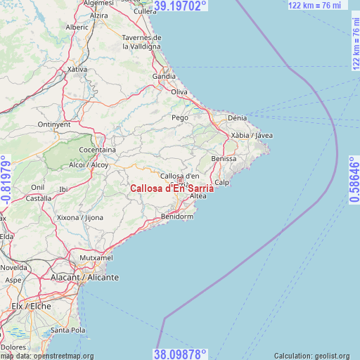
Callosa d'En Sarrià GPS coordinates[2]
38° 39' 0" North, 0° 7' 0.012" West
| Map corner | latitude | longitude |
|---|---|---|
| Upper-left | 39.19702°, | -0.81979° |
| Center: | 38.65°, | -0.11667° |
| Lower-right: | 38.09878°, | 0.58646° |
| Map W x H: | 122.1×122.1 km | = 75.9×75.9mi |
| max Lat: | 43.74134° ⇑84.6% North |
| Callosa d'En Sarrià: | 38.65° |
| min Lat: | ⇓15.4% South 27.64134° |
| min Long | Callosa d'En Sa | max Long |
| -18.00367° | -0.11667° | 4.2899° |
| W 86.3%⇐ | ⇒13.7% E |
Elevation
Elevation of Callosa d'En Sarrià is 203 m = 666 ft, and this is 395 m = 1296 ft below average elevation for this country.
| Max E: |
1682 m = 5518 ft | 81% |
| Avg. | 598 m = 1962 ft | |
| Callosa d'En Sarrià | 203 m = 666 ft | |
Min E: |
0 m = 0 ft | 19% |
See also: Spain elevation on elevation.city.
Geographical zone
Callosa d'En Sarrià is located in North temperate zone (between Tropic of Cancer and the Arctic Circle). Distance of this Northern Tropic circle is 1691.6 km =1051.1 mi to South.| Distance of | km | miles | from Callosa d'En Sarrià |
|---|---|---|---|
| North Pole | 5709.6 | 3547.8 | to North |
| Arctic Circle | 3103.7 | 1928.5 | to North |
| Tropic Cancer | 1691.6 | 1051.1 | to South |
| Equator | 4297.5 | 2670.3 | to South |


Nearby cities:
15 places around Callosa d'En Sarrià: (largest is in red/bold)
• Alcalalí
13 km =8.1 mi,  30°
30°
• Altea
8 km =5 mi,  135°
135°
• Beniardá
9.5 km =5.9 mi,  293°
293°
• Benichembla
11.7 km =7.3 mi,  3°
3°
• Benidorm
12.5 km =7.8 mi,  185°
185°
• Benimantell
8.7 km =5.4 mi, 290°
• Bolulla
2.8 km =1.7 mi,  8°
8°
• Castell de Castells
10.7 km =6.6 mi,  321°
321°
• Finestrat
12.4 km =7.7 mi,  222°
222°
• Murla
12.6 km =7.8 mi, 13°
• Parcent
11.5 km =7.1 mi,  23°
23°
• Polop
3.3 km =2.1 mi,  202°
202°
• Tárbena
5.1 km =3.2 mi, 15°
• l'Alfàs del Pi
7.8 km =4.8 mi,  171°
171°
• la Nucia
4.1 km =2.5 mi, 192°
Sources, notices
• [Note1] Compared only with cities in Spain existing in our database
• [Src1] Map data: © OpenStreetMap contributors (CC-BY-SA)
• [Src2] Other city data from geonames.org with taken over terms of usage.
• [Src3] Geographical zone / Annual Mean Temperature by Robert A. Rohde @ Wikipedia
