Gorafe geodata
Gorafe (Andalusia) is a populated place; located in Spain in Europe/Madrid (GMT+2) time zone. With population of 534 people, there are 3774 cities with bigger population in this country. Compared to other cities in Spain, 91.4% of cities are located further ↑North; 53.7% of cities are located further ←West and 75.8% of cities have lower elevation than Gorafe. Note1


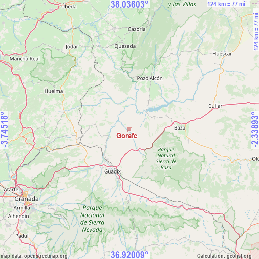
Gorafe GPS coordinates[2]
37° 28' 48.504" North, 3° 2' 31.416" West
| Map corner | latitude | longitude |
|---|---|---|
| Upper-left | 38.03603°, | -3.74518° |
| Center: | 37.48014°, | -3.04206° |
| Lower-right: | 36.92009°, | -2.33893° |
| Map W x H: | 124.1×124.1 km | = 77.1×77.1mi |
| max Lat: | 43.74134° ⇑91.4% North |
| Gorafe: | 37.48014° |
| min Lat: | ⇓8.6% South 27.64134° |
| min Long | Gorafe | max Long |
| -18.00367° | -3.04206° | 4.2899° |
| W 53.7%⇐ | ⇒46.3% E |
Elevation
Elevation of Gorafe is 859 m = 2818 ft, and this is 261 m = 856 ft above average elevation for this country.
| Max E: |
1682 m = 5518 ft | 24.2% |
| Gorafe | 859 m 2818 ft | |
| Avg. | 598 m = 1962 ft | |
Min E: |
0 m = 0 ft | 75.8% |
See also: Spain elevation on elevation.city.
Geographical zone
Gorafe is located in North temperate zone (between Tropic of Cancer and the Arctic Circle). Distance of this Northern Tropic circle is 1561.5 km =970.3 mi to South.| Distance of | km | miles | from Gorafe |
|---|---|---|---|
| North Pole | 5839.7 | 3628.6 | to North |
| Arctic Circle | 3233.8 | 2009.4 | to North |
| Tropic Cancer | 1561.5 | 970.3 | to South |
| Equator | 4167.4 | 2589.5 | to South |


Nearby cities:
15 places around Gorafe: (largest is in red/bold)
• Alamedilla
21 km =13 mi,  302°
302°
• Alicún de Ortega
16.6 km =10.3 mi,  329°
329°
• Baza
23.8 km =14.8 mi,  87°
87°
• Benalúa de Guadix
17.9 km =11.1 mi,  217°
217°
• Cuevas del Campo
17.3 km =10.7 mi,  35°
35°
• Dehesas de Guadix
13.2 km =8.2 mi,  335°
335°
• Fonelas
13.8 km =8.6 mi,  235°
235°
• Freila
13 km =8.1 mi,  64°
64°
• Gor
13.9 km =8.6 mi,  152°
152°
• Guadix
21.9 km =13.6 mi,  203°
203°
• Huélago
20.6 km =12.8 mi,  250°
250°
• Pedro Martínez
16.9 km =10.5 mi,  278°
278°
• Purullena
22.3 km =13.9 mi, 215°
• Villanueva de las Torres
9.5 km =5.9 mi, 334°
• Zújar
19 km =11.8 mi,  68°
68°
Sources, notices
• [Note1] Compared only with cities in Spain existing in our database
• [Src1] Map data: © OpenStreetMap contributors (CC-BY-SA)
• [Src2] Other city data from geonames.org with taken over terms of usage.
• [Src3] Geographical zone / Annual Mean Temperature by Robert A. Rohde @ Wikipedia
