Freila geodata
Freila (Andalusia) is a seat of a third-order administrative division; located in Spain in Europe/Madrid (GMT+2) time zone. With population of 1,051 people, there are 2880 cities with bigger population in this country. Compared to other cities in Spain, 91.1% of cities are located further ↑North; 55.8% of cities are located further ←West and 70.4% of cities have lower elevation than Freila. Note1


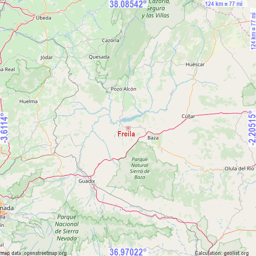
Freila GPS coordinates[2]
37° 31' 47.64" North, 2° 54' 29.808" West
| Map corner | latitude | longitude |
|---|---|---|
| Upper-left | 38.08542°, | -3.6114° |
| Center: | 37.5299°, | -2.90828° |
| Lower-right: | 36.97022°, | -2.20515° |
| Map W x H: | 124×124 km | = 77.1×77.1mi |
| max Lat: | 43.74134° ⇑91.1% North |
| Freila: | 37.5299° |
| min Lat: | ⇓8.9% South 27.64134° |
| min Long | Freila | max Long |
| -18.00367° | -2.90828° | 4.2899° |
| W 55.8%⇐ | ⇒44.2% E |
Elevation
Elevation of Freila is 817 m = 2680 ft, and this is 219 m = 719 ft above average elevation for this country.
| Max E: |
1682 m = 5518 ft | 29.6% |
| Freila | 817 m 2680 ft | |
| Avg. | 598 m = 1962 ft | |
Min E: |
0 m = 0 ft | 70.4% |
See also: Spain elevation on elevation.city.
Geographical zone
Freila is located in North temperate zone (between Tropic of Cancer and the Arctic Circle). Distance of this Northern Tropic circle is 1567 km =973.7 mi to South.| Distance of | km | miles | from Freila |
|---|---|---|---|
| North Pole | 5834.1 | 3625.1 | to North |
| Arctic Circle | 3228.2 | 2005.9 | to North |
| Tropic Cancer | 1567 | 973.7 | to South |
| Equator | 4172.9 | 2592.9 | to South |


Nearby cities:
15 places around Freila: (largest is in red/bold)
• Alicún de Ortega
21.9 km =13.6 mi,  293°
293°
• Baza
12.7 km =7.9 mi,  109°
109°
• Benamaurel
20.1 km =12.5 mi,  64°
64°
• Caniles
19.2 km =11.9 mi,  122°
122°
• Cortes de Baza
18.4 km =11.4 mi,  40°
40°
• Cuevas del Campo
8.8 km =5.5 mi,  347°
347°
• Dehesas de Guadix
18.4 km =11.4 mi, 290°
• Fonelas
26.8 km =16.7 mi,  240°
240°
• Gor
18.7 km =11.6 mi,  197°
197°
• Gorafe
13 km =8.1 mi, 244°
• Hinojares
22.1 km =13.7 mi,  339°
339°
• Pedro Martínez
28.6 km =17.8 mi,  263°
263°
• Pozo Alcón
19.3 km =12 mi, 353°
• Villanueva de las Torres
16.2 km =10.1 mi,  280°
280°
• Zújar
6 km =3.7 mi,  76°
76°
Sources, notices
• [Note1] Compared only with cities in Spain existing in our database
• [Src1] Map data: © OpenStreetMap contributors (CC-BY-SA)
• [Src2] Other city data from geonames.org with taken over terms of usage.
• [Src3] Geographical zone / Annual Mean Temperature by Robert A. Rohde @ Wikipedia
