Guadalmez geodata
Guadalmez (Castille-La Mancha) is a seat of a third-order administrative division; located in Spain in Europe/Madrid (GMT+2) time zone. In our database, there are 6762 cities with bigger population. Compared to other cities in Spain, 84% of cities are located further ↑North; 72.1% of cities are located further →East and 71.2% of cities have higher elevation than Guadalmez. Note1
Administrative division(s):
- Level 1: Castille-La Mancha
- Level 2: Provincia de Ciudad Real
- Level 3: Guadalmez


Guadalmez GPS coordinates[2]
38° 43' 35.94" North, 4° 58' 15.744" West
| Map corner | latitude | longitude |
|---|---|---|
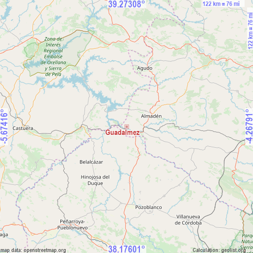
| Upper-left | 39.27308°, | -5.67416° |
| Center: | 38.72665°, | -4.97104° |
| Lower-right: | 38.17601°, | -4.26791° |
| Map W x H: | 122×122 km | = 75.8×75.8mi |
| max Lat: | 43.74134° ⇑84% North |
| Guadalmez: | 38.72665° |
| min Lat: | ⇓16% South 27.64134° |
| min Long | Guadalmez | max Long |
| -18.00367° | -4.97104° | 4.2899° |
| W 27.9%⇐ | ⇒72.1% E |
Elevation
Elevation of Guadalmez is 364 m = 1194 ft, and this is 234 m = 768 ft below average elevation for this country.
| Max E: |
1682 m = 5518 ft | 71.2% |
| Avg. | 598 m = 1962 ft | |
| Guadalmez | 364 m = 1194 ft | |
Min E: |
0 m = 0 ft | 28.8% |
See also: Spain elevation on elevation.city.
Geographical zone
Guadalmez is located in North temperate zone (between Tropic of Cancer and the Arctic Circle). Distance of this Northern Tropic circle is 1700.1 km =1056.4 mi to South.| Distance of | km | miles | from Guadalmez |
|---|---|---|---|
| North Pole | 5701.1 | 3542.5 | to North |
| Arctic Circle | 3095.2 | 1923.3 | to North |
| Tropic Cancer | 1700.1 | 1056.4 | to South |
| Equator | 4306 | 2675.6 | to South |


Nearby cities:
15 places around Guadalmez: (largest is in red/bold)
• Alamillo
16.6 km =10.3 mi,  108°
108°
• Almadén
13.3 km =8.3 mi,  65°
65°
• Baterno
26 km =16.2 mi,  11°
11°
• Belalcázar
23.9 km =14.9 mi,  225°
225°
• Cabeza del Buey
21.6 km =13.4 mi,  268°
268°
• Capilla
14.3 km =8.9 mi,  316°
316°
• Chillón
11.9 km =7.4 mi,  49°
49°
• El Viso
27.1 km =16.8 mi,  176°
176°
• Garlitos
18.3 km =11.4 mi,  338°
338°
• Hinojosa del Duque
29.4 km =18.3 mi,  211°
211°
• Peñalsordo
16.2 km =10.1 mi,  309°
309°
• Santa Eufemia
15.4 km =9.6 mi,  156°
156°
• Siruela
28.7 km =17.8 mi,  346°
346°
• Tamurejo
28.7 km =17.8 mi, 6°
• Valdemanco del Esteras
26.6 km =16.5 mi,  27°
27°
Sources, notices
• [Note1] Compared only with cities in Spain existing in our database
• [Src1] Map data: © OpenStreetMap contributors (CC-BY-SA)
• [Src2] Other city data from geonames.org with taken over terms of usage.
• [Src3] Geographical zone / Annual Mean Temperature by Robert A. Rohde @ Wikipedia
