Beas geodata
Beas (Andalusia) is a seat of a third-order administrative division; located in Spain in Europe/Madrid (GMT+2) time zone. With population of 4,207 people, there are 1435 cities with bigger population in this country. Compared to other cities in Spain, 91.7% of cities are located further ↑North; 93.4% of cities are located further →East and 86.1% of cities have higher elevation than Beas. Note1


Beas GPS coordinates[2]
37° 25' 32.52" North, 6° 47' 35.448" West
| Map corner | latitude | longitude |
|---|---|---|
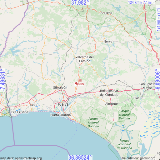
| Upper-left | 37.982°, | -7.49631° |
| Center: | 37.4257°, | -6.79318° |
| Lower-right: | 36.86524°, | -6.09006° |
| Map W x H: | 124.2×124.2 km | = 77.2×77.2mi |
| max Lat: | 43.74134° ⇑91.7% North |
| Beas: | 37.4257° |
| min Lat: | ⇓8.3% South 27.64134° |
| min Long | Beas | max Long |
| -18.00367° | -6.79318° | 4.2899° |
| W 6.6%⇐ | ⇒93.4% E |
Elevation
Elevation of Beas is 121 m = 397 ft, and this is 477 m = 1565 ft below average elevation for this country.
| Max E: |
1682 m = 5518 ft | 86.1% |
| Avg. | 598 m = 1962 ft | |
| Beas | 121 m = 397 ft | |
Min E: |
0 m = 0 ft | 13.9% |
See also: Spain elevation on elevation.city.
Geographical zone
Beas is located in North temperate zone (between Tropic of Cancer and the Arctic Circle). Distance of this Northern Tropic circle is 1555.4 km =966.5 mi to South.| Distance of | km | miles | from Beas |
|---|---|---|---|
| North Pole | 5845.7 | 3632.3 | to North |
| Arctic Circle | 3239.8 | 2013.1 | to North |
| Tropic Cancer | 1555.4 | 966.5 | to South |
| Equator | 4161.3 | 2585.7 | to South |


Nearby cities:
15 places around Beas: (largest is in red/bold)
• Aljaraque
26.7 km =16.6 mi,  229°
229°
• Bollullos par del Condado
24.3 km =15.1 mi,  112°
112°
• Bonares
15 km =9.3 mi,  138°
138°
• Calañas
26.7 km =16.6 mi,  343°
343°
• Gibraleón
16.5 km =10.3 mi,  250°
250°
• Huelva
22 km =13.7 mi,  216°
216°
• La Palma del Condado
21.7 km =13.5 mi,  101°
101°
• Lucena del Puerto
14.7 km =9.1 mi,  157°
157°
• Moguer
17.2 km =10.7 mi,  193°
193°
• Niebla
12.3 km =7.6 mi,  125°
125°
• Palos de la Frontera
23.1 km =14.4 mi,  202°
202°
• San Juan del Puerto
12.8 km =8 mi, 199°
• Trigueros
5.3 km =3.3 mi,  213°
213°
• Valverde del Camino
17 km =10.6 mi,  11°
11°
• Villarrasa
17 km =10.6 mi, 104°
Sources, notices
• [Note1] Compared only with cities in Spain existing in our database
• [Src1] Map data: © OpenStreetMap contributors (CC-BY-SA)
• [Src2] Other city data from geonames.org with taken over terms of usage.
• [Src3] Geographical zone / Annual Mean Temperature by Robert A. Rohde @ Wikipedia
