Bonares geodata
Bonares (Andalusia) is a seat of a third-order administrative division; located in Spain in Europe/Madrid (GMT+2) time zone. With population of 5,257 people, there are 1253 cities with bigger population in this country. Compared to other cities in Spain, 92.8% of cities are located further ↑North; 92.7% of cities are located further →East and 88.5% of cities have higher elevation than Bonares. Note1


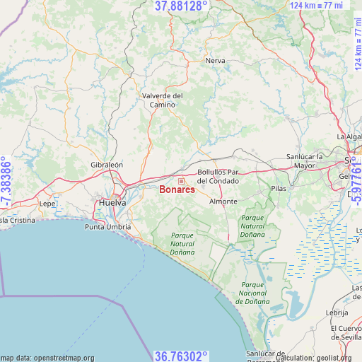
Bonares GPS coordinates[2]
37° 19' 27.228" North, 6° 40' 50.628" West
| Map corner | latitude | longitude |
|---|---|---|
| Upper-left | 37.88128°, | -7.38386° |
| Center: | 37.32423°, | -6.68073° |
| Lower-right: | 36.76302°, | -5.97761° |
| Map W x H: | 124.3×124.3 km | = 77.2×77.2mi |
| max Lat: | 43.74134° ⇑92.8% North |
| Bonares: | 37.32423° |
| min Lat: | ⇓7.2% South 27.64134° |
| min Long | Bonares | max Long |
| -18.00367° | -6.68073° | 4.2899° |
| W 7.3%⇐ | ⇒92.7% E |
Elevation
Elevation of Bonares is 87 m = 285 ft, and this is 511 m = 1677 ft below average elevation for this country.
| Max E: |
1682 m = 5518 ft | 88.5% |
| Avg. | 598 m = 1962 ft | |
| Bonares | 87 m = 285 ft | |
Min E: |
0 m = 0 ft | 11.5% |
See also: Spain elevation on elevation.city.
Geographical zone
Bonares is located in North temperate zone (between Tropic of Cancer and the Arctic Circle). Distance of this Northern Tropic circle is 1544.1 km =959.5 mi to South.| Distance of | km | miles | from Bonares |
|---|---|---|---|
| North Pole | 5857 | 3639.4 | to North |
| Arctic Circle | 3251.1 | 2020.1 | to North |
| Tropic Cancer | 1544.1 | 959.5 | to South |
| Equator | 4150.1 | 2578.8 | to South |


Nearby cities:
15 places around Bonares: (largest is in red/bold)
• Almonte
16 km =9.9 mi,  114°
114°
• Beas
15 km =9.3 mi,  318°
318°
• Bollullos par del Condado
12.6 km =7.8 mi,  81°
81°
• Huelva
23.8 km =14.8 mi,  254°
254°
• La Palma del Condado
13.3 km =8.3 mi,  58°
58°
• Lucena del Puerto
4.8 km =3 mi,  242°
242°
• Manzanilla
23.1 km =14.4 mi,  71°
71°
• Mazagón
24.5 km =15.2 mi,  211°
211°
• Moguer
15 km =9.3 mi, 248°
• Niebla
4.2 km =2.6 mi,  2°
2°
• Palos de la Frontera
21.4 km =13.3 mi, 242°
• San Juan del Puerto
14.2 km =8.8 mi,  266°
266°
• Trigueros
14.6 km =9.1 mi,  298°
298°
• Villalba del Alcor
19.9 km =12.4 mi, 65°
• Villarrasa
9.7 km =6 mi,  42°
42°
Sources, notices
• [Note1] Compared only with cities in Spain existing in our database
• [Src1] Map data: © OpenStreetMap contributors (CC-BY-SA)
• [Src2] Other city data from geonames.org with taken over terms of usage.
• [Src3] Geographical zone / Annual Mean Temperature by Robert A. Rohde @ Wikipedia
