Moguer geodata
Moguer (Andalusia) is a seat of a third-order administrative division; located in Spain in Europe/Madrid (GMT+2) time zone. With population of 19,569 people, there are 483 cities with bigger population in this country. Compared to other cities in Spain, 93.2% of cities are located further ↑North; 93.7% of cities are located further →East and 90.8% of cities have higher elevation than Moguer. Note1


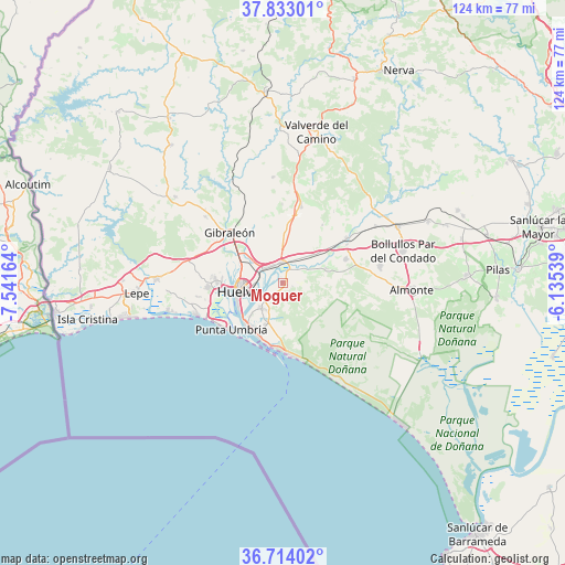
Moguer GPS coordinates[2]
37° 16' 32.124" North, 6° 50' 18.636" West
| Map corner | latitude | longitude |
|---|---|---|
| Upper-left | 37.83301°, | -7.54164° |
| Center: | 37.27559°, | -6.83851° |
| Lower-right: | 36.71402°, | -6.13539° |
| Map W x H: | 124.4×124.4 km | = 77.3×77.3mi |
| max Lat: | 43.74134° ⇑93.2% North |
| Moguer: | 37.27559° |
| min Lat: | ⇓6.8% South 27.64134° |
| min Long | Moguer | max Long |
| -18.00367° | -6.83851° | 4.2899° |
| W 6.3%⇐ | ⇒93.7% E |
Elevation
Elevation of Moguer is 54 m = 177 ft, and this is 544 m = 1785 ft below average elevation for this country.
| Max E: |
1682 m = 5518 ft | 90.8% |
| Avg. | 598 m = 1962 ft | |
| Moguer | 54 m = 177 ft | |
Min E: |
0 m = 0 ft | 9.2% |
See also: Spain elevation on elevation.city.
Geographical zone
Moguer is located in North temperate zone (between Tropic of Cancer and the Arctic Circle). Distance of this Northern Tropic circle is 1538.7 km =956.1 mi to South.| Distance of | km | miles | from Moguer |
|---|---|---|---|
| North Pole | 5862.4 | 3642.7 | to North |
| Arctic Circle | 3256.5 | 2023.5 | to North |
| Tropic Cancer | 1538.7 | 956.1 | to South |
| Equator | 4144.7 | 2575.4 | to South |


Nearby cities:
15 places around Moguer: (largest is in red/bold)
• Aljaraque
16.3 km =10.1 mi,  267°
267°
• Beas
17.2 km =10.7 mi,  13°
13°
• Bollullos par del Condado
27.4 km =17 mi,  74°
74°
• Bonares
15 km =9.3 mi, 68°
• El Rompido
25.9 km =16.1 mi,  255°
255°
• Gibraleón
16.1 km =10 mi,  314°
314°
• Huelva
9 km =5.6 mi, 263°
• Lucena del Puerto
10.2 km =6.3 mi, 71°
• Mazagón
15.4 km =9.6 mi,  176°
176°
• Niebla
17.1 km =10.6 mi,  55°
55°
• Palos de la Frontera
6.7 km =4.2 mi,  227°
227°
• Punta Umbría
15.3 km =9.5 mi, 227°
• San Juan del Puerto
4.6 km =2.9 mi,  356°
356°
• Trigueros
12.3 km =7.6 mi,  4°
4°
• Villarrasa
24.1 km =15 mi, 58°
Sources, notices
• [Note1] Compared only with cities in Spain existing in our database
• [Src1] Map data: © OpenStreetMap contributors (CC-BY-SA)
• [Src2] Other city data from geonames.org with taken over terms of usage.
• [Src3] Geographical zone / Annual Mean Temperature by Robert A. Rohde @ Wikipedia
