San Juan del Puerto geodata
San Juan del Puerto (Andalusia) is a seat of a third-order administrative division; located in Spain in Europe/Madrid (GMT+2) time zone. With population of 6,834 people, there are 1053 cities with bigger population in this country. Compared to other cities in Spain, 92.9% of cities are located further ↑North; 93.7% of cities are located further →East and 98.7% of cities have higher elevation than San Juan del Puerto. Note1
Administrative division(s):
- Level 1: Andalusia
- Level 2: Provincia de Huelva
- Level 3: San Juan del Puerto


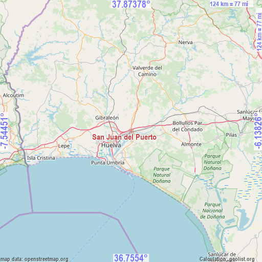
San Juan del Puerto GPS coordinates[2]
37° 19' 0.012" North, 6° 50' 29.004" West
| Map corner | latitude | longitude |
|---|---|---|
| Upper-left | 37.87378°, | -7.54451° |
| Center: | 37.31667°, | -6.84139° |
| Lower-right: | 36.7554°, | -6.13826° |
| Map W x H: | 124.4×124.4 km | = 77.3×77.3mi |
| max Lat: | 43.74134° ⇑92.9% North |
| San Juan del Puerto: | 37.31667° |
| min Lat: | ⇓7.1% South 27.64134° |
| min Long | San Juan del Pu | max Long |
| -18.00367° | -6.84139° | 4.2899° |
| W 6.3%⇐ | ⇒93.7% E |
Elevation
Elevation of San Juan del Puerto is 9 m = 30 ft, and this is 589 m = 1932 ft below average elevation for this country.
| Max E: |
1682 m = 5518 ft | 98.7% |
| Avg. | 598 m = 1962 ft | |
| San Juan del Puerto | 9 m = 30 ft | |
Min E: |
0 m = 0 ft | 1.3% |
See also: Spain elevation on elevation.city.
Geographical zone
San Juan del Puerto is located in North temperate zone (between Tropic of Cancer and the Arctic Circle). Distance of this Northern Tropic circle is 1543.3 km =959 mi to South.| Distance of | km | miles | from San Juan del Puerto |
|---|---|---|---|
| North Pole | 5857.8 | 3639.9 | to North |
| Arctic Circle | 3251.9 | 2020.6 | to North |
| Tropic Cancer | 1543.3 | 959 | to South |
| Equator | 4149.2 | 2578.2 | to South |


Nearby cities:
15 places around San Juan del Puerto: (largest is in red/bold)
• Aljaraque
16.9 km =10.5 mi,  252°
252°
• Beas
12.8 km =8 mi,  19°
19°
• Bollullos par del Condado
26.8 km =16.7 mi,  84°
84°
• Bonares
14.2 km =8.8 mi,  86°
86°
• Gibraleón
13.1 km =8.1 mi,  300°
300°
• Huelva
10.4 km =6.5 mi,  237°
237°
• La Palma del Condado
26.7 km =16.6 mi,  73°
73°
• Lucena del Puerto
10 km =6.2 mi,  98°
98°
• Mazagón
20 km =12.4 mi,  176°
176°
• Moguer
4.6 km =2.9 mi, 176°
• Niebla
15.2 km =9.4 mi, 70°
• Palos de la Frontera
10.3 km =6.4 mi,  207°
207°
• Punta Umbría
18.6 km =11.6 mi,  216°
216°
• Trigueros
7.8 km =4.8 mi,  9°
9°
• Villarrasa
22.3 km =13.9 mi, 68°
Sources, notices
• [Note1] Compared only with cities in Spain existing in our database
• [Src1] Map data: © OpenStreetMap contributors (CC-BY-SA)
• [Src2] Other city data from geonames.org with taken over terms of usage.
• [Src3] Geographical zone / Annual Mean Temperature by Robert A. Rohde @ Wikipedia
