Los Barrios geodata
Los Barrios (Andalusia) is a populated place; located in Spain in Europe/Madrid (GMT+2) time zone. With population of 22,311 people, there are 418 cities with bigger population in this country. Compared to other cities in Spain, 98.3% of cities are located further ↑North; 78.6% of cities are located further →East and 95.4% of cities have higher elevation than Los Barrios. Note1


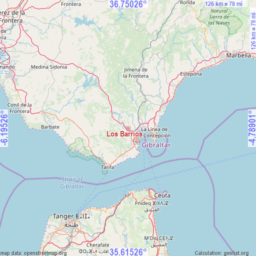
Los Barrios GPS coordinates[2]
36° 11' 5.352" North, 5° 29' 31.668" West
| Map corner | latitude | longitude |
|---|---|---|
| Upper-left | 36.75026°, | -6.19526° |
| Center: | 36.18482°, | -5.49213° |
| Lower-right: | 35.61526°, | -4.78901° |
| Map W x H: | 126.2×126.2 km | = 78.4×78.4mi |
| max Lat: | 43.74134° ⇑98.3% North |
| Los Barrios: | 36.18482° |
| min Lat: | ⇓1.7% South 27.64134° |
| min Long | Los Barrios | max Long |
| -18.00367° | -5.49213° | 4.2899° |
| W 21.4%⇐ | ⇒78.6% E |
Elevation
Elevation of Los Barrios is 23 m = 75 ft, and this is 575 m = 1886 ft below average elevation for this country.
| Max E: |
1682 m = 5518 ft | 95.4% |
| Avg. | 598 m = 1962 ft | |
| Los Barrios | 23 m = 75 ft | |
Min E: |
0 m = 0 ft | 4.6% |
See also: Spain elevation on elevation.city.
Geographical zone
Los Barrios is located in North temperate zone (between Tropic of Cancer and the Arctic Circle). Distance of this Northern Tropic circle is 1417.5 km =880.8 mi to South.| Distance of | km | miles | from Los Barrios |
|---|---|---|---|
| North Pole | 5983.7 | 3718.1 | to North |
| Arctic Circle | 3377.8 | 2098.9 | to North |
| Tropic Cancer | 1417.5 | 880.8 | to South |
| Equator | 4023.4 | 2500 | to South |


Nearby cities:
15 places around Los Barrios: (largest is in red/bold)
• Alcalá de los Gazules
37.2 km =23.1 mi,  326°
326°
• Algeciras
6.8 km =4.2 mi,  146°
146°
• Barbate
38.6 km =24 mi,  271°
271°
• Benalup-Casas Viejas
33.7 km =20.9 mi,  301°
301°
• Benzú
31.7 km =19.7 mi,  160°
160°
• Casares
34.5 km =21.4 mi,  32°
32°
• Castellar de la Frontera
15.1 km =9.4 mi,  13°
13°
• Ceuta
36.3 km =22.6 mi, 154°
• Jimena de la Frontera
28 km =17.4 mi, 7°
• La Línea de la Concepción
13.1 km =8.1 mi,  98°
98°
• Manilva
30.4 km =18.9 mi,  45°
45°
• San Enrique de Guadiaro
22.4 km =13.9 mi, 53°
• San Roque
10.1 km =6.3 mi,  73°
73°
• Tarifa
21.6 km =13.4 mi,  208°
208°
• Zahara de los Atunes
32.2 km =20 mi,  260°
260°
Sources, notices
• [Note1] Compared only with cities in Spain existing in our database
• [Src1] Map data: © OpenStreetMap contributors (CC-BY-SA)
• [Src2] Other city data from geonames.org with taken over terms of usage.
• [Src3] Geographical zone / Annual Mean Temperature by Robert A. Rohde @ Wikipedia
