Tarifa geodata
Tarifa (Andalusia) is a seat of a third-order administrative division; located in Spain in Europe/Madrid (GMT+2) time zone. With population of 17,793 people, there are 532 cities with bigger population in this country. Compared to other cities in Spain, 98.3% of cities are located further ↑North; 80.3% of cities are located further →East and 95.6% of cities have higher elevation than Tarifa. Note1


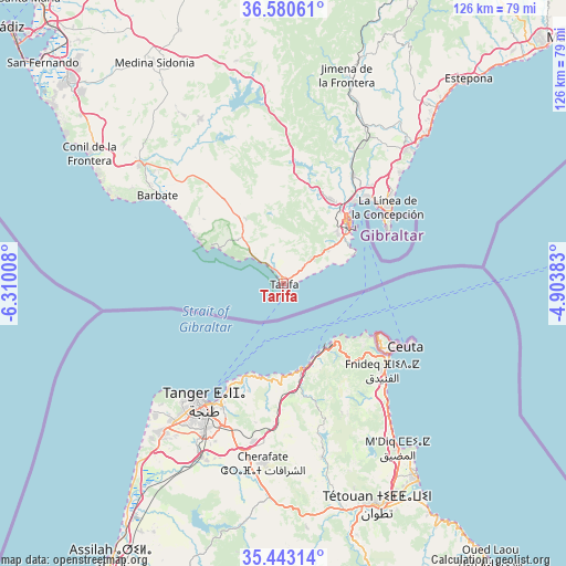
Tarifa GPS coordinates[2]
36° 0' 50.148" North, 5° 36' 25.02" West
| Map corner | latitude | longitude |
|---|---|---|
| Upper-left | 36.58061°, | -6.31008° |
| Center: | 36.01393°, | -5.60695° |
| Lower-right: | 35.44314°, | -4.90383° |
| Map W x H: | 126.5×126.5 km | = 78.6×78.6mi |
| max Lat: | 43.74134° ⇑98.3% North |
| Tarifa: | 36.01393° |
| min Lat: | ⇓1.7% South 27.64134° |
| min Long | Tarifa | max Long |
| -18.00367° | -5.60695° | 4.2899° |
| W 19.7%⇐ | ⇒80.3% E |
Elevation
Elevation of Tarifa is 22 m = 72 ft, and this is 576 m = 1890 ft below average elevation for this country.
| Max E: |
1682 m = 5518 ft | 95.6% |
| Avg. | 598 m = 1962 ft | |
| Tarifa | 22 m = 72 ft | |
Min E: |
0 m = 0 ft | 4.4% |
See also: Spain elevation on elevation.city.
Geographical zone
Tarifa is located in North temperate zone (between Tropic of Cancer and the Arctic Circle). Distance of this Northern Tropic circle is 1398.5 km =869 mi to South.| Distance of | km | miles | from Tarifa |
|---|---|---|---|
| North Pole | 6002.7 | 3729.9 | to North |
| Arctic Circle | 3396.8 | 2110.7 | to North |
| Tropic Cancer | 1398.5 | 869 | to South |
| Equator | 4004.4 | 2488.2 | to South |


Nearby cities:
15 places around Tarifa: (largest is in red/bold)
• Alcalá de los Gazules
50.9 km =31.6 mi,  348°
348°
• Algeciras
19.3 km =12 mi,  46°
46°
• Barbate
34.6 km =21.5 mi,  305°
305°
• Benalup-Casas Viejas
41.1 km =25.5 mi,  333°
333°
• Benzú
23.7 km =14.7 mi,  117°
117°
• Castellar de la Frontera
36.4 km =22.6 mi,  22°
22°
• Ceuta
29.3 km =18.2 mi, 118°
• Jimena de la Frontera
48.8 km =30.3 mi, 16°
• La Línea de la Concepción
28.9 km =18 mi, 53°
• Los Barrios
21.6 km =13.4 mi,  28°
28°
• Manilva
51.5 km =32 mi,  38°
38°
• San Enrique de Guadiaro
43 km =26.7 mi, 41°
• San Roque
29.6 km =18.4 mi, 42°
• Vejer de la Frontera
41.8 km =26 mi, 309°
• Zahara de los Atunes
25.5 km =15.8 mi,  302°
302°
Sources, notices
• [Note1] Compared only with cities in Spain existing in our database
• [Src1] Map data: © OpenStreetMap contributors (CC-BY-SA)
• [Src2] Other city data from geonames.org with taken over terms of usage.
• [Src3] Geographical zone / Annual Mean Temperature by Robert A. Rohde @ Wikipedia
