Aspe geodata
Aspe (Valencia) is a seat of a third-order administrative division; located in Spain in Europe/Madrid (GMT+2) time zone. With population of 20,180 people, there are 476 cities with bigger population in this country. Compared to other cities in Spain, 86.5% of cities are located further ↑North; 79.2% of cities are located further ←West and 78.6% of cities have higher elevation than Aspe. Note1


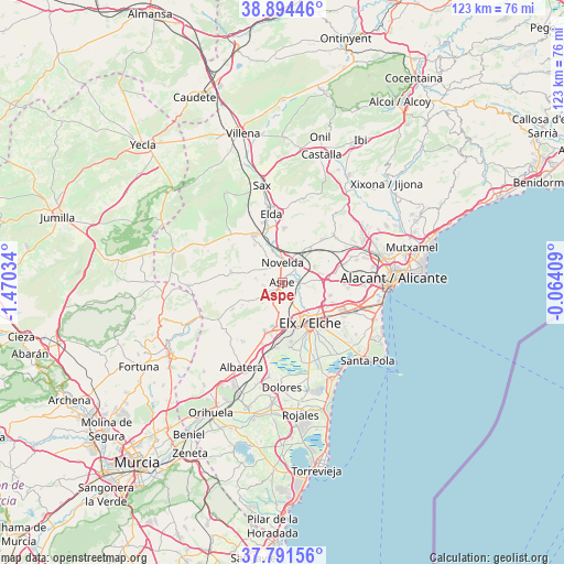
Aspe GPS coordinates[2]
38° 20' 42.396" North, 0° 46' 1.956" West
| Map corner | latitude | longitude |
|---|---|---|
| Upper-left | 38.89446°, | -1.47034° |
| Center: | 38.34511°, | -0.76721° |
| Lower-right: | 37.79156°, | -0.06409° |
| Map W x H: | 122.6×122.6 km | = 76.2×76.2mi |
| max Lat: | 43.74134° ⇑86.5% North |
| Aspe: | 38.34511° |
| min Lat: | ⇓13.5% South 27.64134° |
| min Long | Aspe | max Long |
| -18.00367° | -0.76721° | 4.2899° |
| W 79.2%⇐ | ⇒20.8% E |
Elevation
Elevation of Aspe is 245 m = 804 ft, and this is 353 m = 1158 ft below average elevation for this country.
| Max E: |
1682 m = 5518 ft | 78.6% |
| Avg. | 598 m = 1962 ft | |
| Aspe | 245 m = 804 ft | |
Min E: |
0 m = 0 ft | 21.4% |
See also: Spain elevation on elevation.city.
Geographical zone
Aspe is located in North temperate zone (between Tropic of Cancer and the Arctic Circle). Distance of this Northern Tropic circle is 1657.7 km =1030 mi to South.| Distance of | km | miles | from Aspe |
|---|---|---|---|
| North Pole | 5743.5 | 3568.8 | to North |
| Arctic Circle | 3137.6 | 1949.6 | to North |
| Tropic Cancer | 1657.7 | 1030 | to South |
| Equator | 4263.6 | 2649.3 | to South |


Nearby cities:
15 places around Aspe: (largest is in red/bold)
• Agost
15.4 km =9.6 mi,  46°
46°
• Albatera
20.6 km =12.8 mi,  206°
206°
• Algueña
20.7 km =12.9 mi,  268°
268°
• Catral
20.7 km =12.9 mi,  188°
188°
• Crevillente
11.2 km =7 mi,  199°
199°
• Elche
10.9 km =6.8 mi,  147°
147°
• Elda
14.9 km =9.3 mi,  351°
351°
• Hondón de las Nieves
8.5 km =5.3 mi,  241°
241°
• Hondón de los Frailes
16.2 km =10.1 mi, 240°
• La Romana
11.7 km =7.3 mi,  282°
282°
• Monforte del Cid
5.2 km =3.2 mi,  40°
40°
• Monóvar
12.2 km =7.6 mi,  328°
328°
• Novelda
4.4 km =2.7 mi,  359°
359°
• San Isidro
20.2 km =12.6 mi, 198°
• San Vicent del Raspeig
21.8 km =13.5 mi,  74°
74°
Sources, notices
• [Note1] Compared only with cities in Spain existing in our database
• [Src1] Map data: © OpenStreetMap contributors (CC-BY-SA)
• [Src2] Other city data from geonames.org with taken over terms of usage.
• [Src3] Geographical zone / Annual Mean Temperature by Robert A. Rohde @ Wikipedia
