Elche geodata
Elche (Valencia) is a seat of a third-order administrative division; located in Spain in Europe/Madrid (GMT+2) time zone. With population of 230,112 people, there are 24 cities with bigger population in this country. Compared to other cities in Spain, 86.9% of cities are located further ↑North; 79.8% of cities are located further ←West and 89% of cities have higher elevation than Elche. Note1


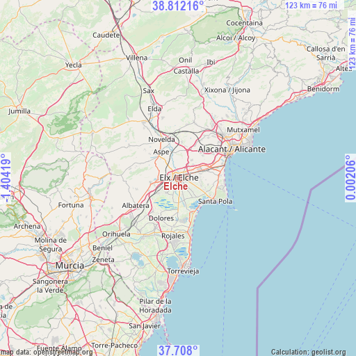
Elche GPS coordinates[2]
38° 15' 43.848" North, 0° 42' 3.852" West
| Map corner | latitude | longitude |
|---|---|---|
| Upper-left | 38.81216°, | -1.40419° |
| Center: | 38.26218°, | -0.70107° |
| Lower-right: | 37.708°, | 0.00206° |
| Map W x H: | 122.8×122.8 km | = 76.3×76.3mi |
| max Lat: | 43.74134° ⇑86.9% North |
| Elche: | 38.26218° |
| min Lat: | ⇓13.1% South 27.64134° |
| min Long | Elche | max Long |
| -18.00367° | -0.70107° | 4.2899° |
| W 79.8%⇐ | ⇒20.2% E |
Elevation
Elevation of Elche is 81 m = 266 ft, and this is 517 m = 1696 ft below average elevation for this country.
| Max E: |
1682 m = 5518 ft | 89% |
| Avg. | 598 m = 1962 ft | |
| Elche | 81 m = 266 ft | |
Min E: |
0 m = 0 ft | 11% |
See also: Elche elevation on elevation.city.
Geographical zone
Elche is located in North temperate zone (between Tropic of Cancer and the Arctic Circle). Distance of this Northern Tropic circle is 1648.4 km =1024.3 mi to South.| Distance of | km | miles | from Elche |
|---|---|---|---|
| North Pole | 5752.7 | 3574.6 | to North |
| Arctic Circle | 3146.8 | 1955.3 | to North |
| Tropic Cancer | 1648.4 | 1024.3 | to South |
| Equator | 4254.4 | 2643.6 | to South |


Nearby cities:
15 places around Elche: (largest is in red/bold)
• Albatera
17.5 km =10.9 mi,  238°
238°
• Almoradí
18.8 km =11.7 mi,  204°
204°
• Aspe
10.9 km =6.8 mi,  327°
327°
• Catral
14.3 km =8.9 mi,  218°
218°
• Crevillente
9.6 km =6 mi,  261°
261°
• Daya Nueva
17.4 km =10.8 mi, 197°
• Daya Vieja
17.8 km =11.1 mi,  190°
190°
• Dolores
14.9 km =9.3 mi, 204°
• Guardamar del Segura
19.5 km =12.1 mi,  168°
168°
• Hondón de las Nieves
14.2 km =8.8 mi,  291°
291°
• Monforte del Cid
13.3 km =8.3 mi,  349°
349°
• Novelda
14.8 km =9.2 mi,  336°
336°
• Rojales
19.5 km =12.1 mi, 186°
• San Isidro
15.6 km =9.7 mi,  230°
230°
• Santa Pola
14.2 km =8.8 mi,  123°
123°
Sources, notices
• [Note1] Compared only with cities in Spain existing in our database
• [Src1] Map data: © OpenStreetMap contributors (CC-BY-SA)
• [Src2] Other city data from geonames.org with taken over terms of usage.
• [Src3] Geographical zone / Annual Mean Temperature by Robert A. Rohde @ Wikipedia
