Hondón de los Frailes geodata
Hondón de los Frailes (Valencia) is a seat of a third-order administrative division; located in Spain in Europe/Madrid (GMT+2) time zone. With population of 1,058 people, there are 2869 cities with bigger population in this country. Compared to other cities in Spain, 86.8% of cities are located further ↑North; 77.7% of cities are located further ←West and 67.7% of cities have higher elevation than Hondón de los Frailes. Note1
Administrative division(s):
- Level 1: Valencia
- Level 2: Provincia de Alicante
- Level 3: Hondón de los Frailes
Current local time in Hondón de los Frailes:
10:42 PM, ThursdayDifference from your time zone: hours


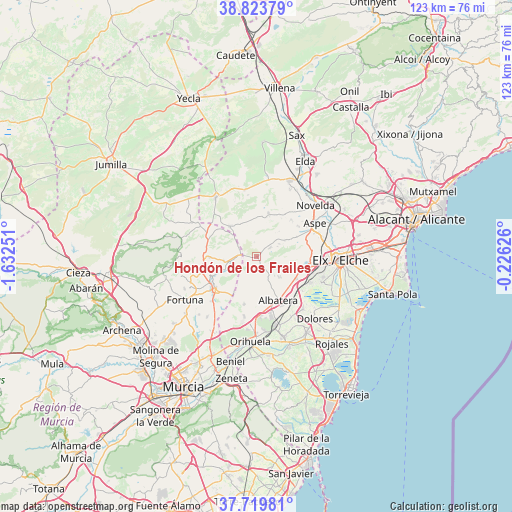
Hondón de los Frailes GPS coordinates[2]
38° 16' 26.04" North, 0° 55' 45.768" West
| Map corner | latitude | longitude |
|---|---|---|
| Upper-left | 38.82379°, | -1.63251° |
| Center: | 38.2739°, | -0.92938° |
| Lower-right: | 37.71981°, | -0.22626° |
| Map W x H: | 122.8×122.8 km | = 76.3×76.3mi |
| max Lat: | 43.74134° ⇑86.8% North |
| Hondón de los Frailes: | 38.2739° |
| min Lat: | ⇓13.2% South 27.64134° |
| min Long | Hondón de los | max Long |
| -18.00367° | -0.92938° | 4.2899° |
| W 77.7%⇐ | ⇒22.3% E |
Elevation
Elevation of Hondón de los Frailes is 423 m = 1388 ft, and this is 175 m = 574 ft below average elevation for this country.
| Max E: |
1682 m = 5518 ft | 67.7% |
| Avg. | 598 m = 1962 ft | |
| Hondón de los Frailes | 423 m = 1388 ft | |
Min E: |
0 m = 0 ft | 32.3% |
See also: Spain elevation on elevation.city.
Geographical zone
Hondón de los Frailes is located in North temperate zone (between Tropic of Cancer and the Arctic Circle). Distance of this Northern Tropic circle is 1649.7 km =1025.1 mi to South.| Distance of | km | miles | from Hondón de los Frailes |
|---|---|---|---|
| North Pole | 5751.4 | 3573.8 | to North |
| Arctic Circle | 3145.5 | 1954.5 | to North |
| Tropic Cancer | 1649.7 | 1025.1 | to South |
| Equator | 4255.7 | 2644.4 | to South |


Nearby cities:
15 places around Hondón de los Frailes: (largest is in red/bold)
• Abanilla
12.4 km =7.7 mi,  232°
232°
• Albatera
11.7 km =7.3 mi,  154°
154°
• Algueña
9.8 km =6.1 mi,  317°
317°
• Aspe
16.2 km =10.1 mi,  60°
60°
• Benferri
15 km =9.3 mi,  190°
190°
• Callosa de Segura
17.2 km =10.7 mi,  164°
164°
• Catral
16.8 km =10.4 mi,  138°
138°
• Cox
15.2 km =9.4 mi,  165°
165°
• Crevillente
10.8 km =6.7 mi,  104°
104°
• Granja de Rocamora
14 km =8.7 mi, 166°
• Hondón de las Nieves
7.7 km =4.8 mi, 59°
• La Romana
10.8 km =6.7 mi,  14°
14°
• Pinoso
17.3 km =10.7 mi,  325°
325°
• Redován
17.6 km =10.9 mi, 174°
• San Isidro
13.8 km =8.6 mi, 144°
Sources, notices
• [Note1] Compared only with cities in Spain existing in our database
• [Src1] Map data: © OpenStreetMap contributors (CC-BY-SA)
• [Src2] Other city data from geonames.org with taken over terms of usage.
• [Src3] Geographical zone / Annual Mean Temperature by Robert A. Rohde @ Wikipedia
