Almendralejo geodata
Almendralejo (Extremadura) is a seat of a third-order administrative division; located in Spain in Europe/Madrid (GMT+2) time zone. With population of 33,588 people, there are 267 cities with bigger population in this country. Compared to other cities in Spain, 84.4% of cities are located further ↑North; 90.4% of cities are located further →East and 72.6% of cities have higher elevation than Almendralejo. Note1
Administrative division(s):
- Level 1: Extremadura
- Level 2: Provincia de Badajoz
- Level 3: Almendralejo


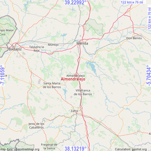
Almendralejo GPS coordinates[2]
38° 40' 59.376" North, 6° 24' 26.892" West
| Map corner | latitude | longitude |
|---|---|---|
| Upper-left | 39.22992°, | -7.11059° |
| Center: | 38.68316°, | -6.40747° |
| Lower-right: | 38.13219°, | -5.70434° |
| Map W x H: | 122.1×122.1 km | = 75.9×75.9mi |
| max Lat: | 43.74134° ⇑84.4% North |
| Almendralejo: | 38.68316° |
| min Lat: | ⇓15.6% South 27.64134° |
| min Long | Almendralejo | max Long |
| -18.00367° | -6.40747° | 4.2899° |
| W 9.6%⇐ | ⇒90.4% E |
Elevation
Elevation of Almendralejo is 338 m = 1109 ft, and this is 260 m = 853 ft below average elevation for this country.
| Max E: |
1682 m = 5518 ft | 72.6% |
| Avg. | 598 m = 1962 ft | |
| Almendralejo | 338 m = 1109 ft | |
Min E: |
0 m = 0 ft | 27.4% |
See also: Spain elevation on elevation.city.
Geographical zone
Almendralejo is located in North temperate zone (between Tropic of Cancer and the Arctic Circle). Distance of this Northern Tropic circle is 1695.2 km =1053.3 mi to South.| Distance of | km | miles | from Almendralejo |
|---|---|---|---|
| North Pole | 5705.9 | 3545.5 | to North |
| Arctic Circle | 3100 | 1926.3 | to North |
| Tropic Cancer | 1695.2 | 1053.3 | to South |
| Equator | 4301.2 | 2672.6 | to South |


Nearby cities:
15 places around Almendralejo: (largest is in red/bold)
• Aceuchal
8 km =5 mi,  239°
239°
• Alange
18 km =11.2 mi,  51°
51°
• Arroyo de San Serván
19.5 km =12.1 mi,  348°
348°
• Calamonte
22.9 km =14.2 mi,  4°
4°
• Corte de Peleas
23.3 km =14.5 mi,  281°
281°
• Don Álvaro
21.7 km =13.5 mi,  32°
32°
• Fuente del Maestre
17.8 km =11.1 mi,  191°
191°
• Puebla del Prior
22.3 km =13.9 mi,  124°
124°
• Ribera del Fresno
20.8 km =12.9 mi,  134°
134°
• Santa Marta
20.6 km =12.8 mi,  248°
248°
• Solana de los Barros
12.3 km =7.6 mi,  292°
292°
• Torremegía
12.2 km =7.6 mi,  12°
12°
• Villafranca de los Barros
14.8 km =9.2 mi,  155°
155°
• Villalba de los Barros
11.8 km =7.3 mi,  228°
228°
• Zarza de Alange
22.3 km =13.9 mi, 47°
Sources, notices
• [Note1] Compared only with cities in Spain existing in our database
• [Src1] Map data: © OpenStreetMap contributors (CC-BY-SA)
• [Src2] Other city data from geonames.org with taken over terms of usage.
• [Src3] Geographical zone / Annual Mean Temperature by Robert A. Rohde @ Wikipedia
