Zarza de Alange geodata
Zarza de Alange (Extremadura) is a populated place; located in Spain in Europe/Madrid (GMT+2) time zone. With population of 3,580 people, there are 1569 cities with bigger population in this country. Compared to other cities in Spain, 83.1% of cities are located further ↑North; 88.7% of cities are located further →East and 75.9% of cities have higher elevation than Zarza de Alange. Note1


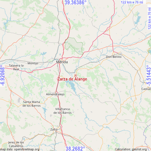
Zarza de Alange GPS coordinates[2]
38° 49' 5.304" North, 6° 13' 3.216" West
| Map corner | latitude | longitude |
|---|---|---|
| Upper-left | 39.36386°, | -6.92068° |
| Center: | 38.81814°, | -6.21756° |
| Lower-right: | 38.2682°, | -5.51443° |
| Map W x H: | 121.8×121.8 km | = 75.7×75.7mi |
| max Lat: | 43.74134° ⇑83.1% North |
| Zarza de Alange: | 38.81814° |
| min Lat: | ⇓16.9% South 27.64134° |
| min Long | Zarza de Alange | max Long |
| -18.00367° | -6.21756° | 4.2899° |
| W 11.3%⇐ | ⇒88.7% E |
Elevation
Elevation of Zarza de Alange is 286 m = 938 ft, and this is 312 m = 1024 ft below average elevation for this country.
| Max E: |
1682 m = 5518 ft | 75.9% |
| Avg. | 598 m = 1962 ft | |
| Zarza de Alange | 286 m = 938 ft | |
Min E: |
0 m = 0 ft | 24.1% |
See also: Spain elevation on elevation.city.
Geographical zone
Zarza de Alange is located in North temperate zone (between Tropic of Cancer and the Arctic Circle). Distance of this Northern Tropic circle is 1710.3 km =1062.7 mi to South.| Distance of | km | miles | from Zarza de Alange |
|---|---|---|---|
| North Pole | 5690.9 | 3536.2 | to North |
| Arctic Circle | 3085 | 1916.9 | to North |
| Tropic Cancer | 1710.3 | 1062.7 | to South |
| Equator | 4316.2 | 2682 | to South |


Nearby cities:
15 places around Zarza de Alange: (largest is in red/bold)
• Alange
4.4 km =2.7 mi,  213°
213°
• Calamonte
16.7 km =10.4 mi,  297°
297°
• Cristina
10.5 km =6.5 mi,  78°
78°
• Don Álvaro
6 km =3.7 mi, 304°
• Guareña
11.2 km =7 mi,  65°
65°
• Manchita
17.1 km =10.6 mi,  91°
91°
• Mérida
15.4 km =9.6 mi,  314°
314°
• Oliva de Mérida
8.7 km =5.4 mi,  110°
110°
• Palomas
15.7 km =9.8 mi,  152°
152°
• San Pedro de Mérida
14.9 km =9.3 mi,  10°
10°
• Torremegía
14.1 km =8.8 mi,  257°
257°
• Trujillanos
15.3 km =9.5 mi,  346°
346°
• Valdetorres
16.9 km =10.5 mi,  50°
50°
• Valverde de Mérida
10.4 km =6.5 mi,  358°
358°
• Villagonzalo
5.3 km =3.3 mi,  19°
19°
Sources, notices
• [Note1] Compared only with cities in Spain existing in our database
• [Src1] Map data: © OpenStreetMap contributors (CC-BY-SA)
• [Src2] Other city data from geonames.org with taken over terms of usage.
• [Src3] Geographical zone / Annual Mean Temperature by Robert A. Rohde @ Wikipedia
