Aceuchal geodata
Aceuchal (Extremadura) is a seat of a third-order administrative division; located in Spain in Europe/Madrid (GMT+2) time zone. With population of 5,408 people, there are 1231 cities with bigger population in this country. Compared to other cities in Spain, 84.6% of cities are located further ↑North; 91.1% of cities are located further →East and 74.4% of cities have higher elevation than Aceuchal. Note1


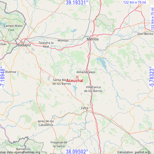
Aceuchal GPS coordinates[2]
38° 38' 46.572" North, 6° 29' 10.896" West
| Map corner | latitude | longitude |
|---|---|---|
| Upper-left | 39.19331°, | -7.18948° |
| Center: | 38.64627°, | -6.48636° |
| Lower-right: | 38.09502°, | -5.78323° |
| Map W x H: | 122.1×122.1 km | = 75.9×75.9mi |
| max Lat: | 43.74134° ⇑84.6% North |
| Aceuchal: | 38.64627° |
| min Lat: | ⇓15.4% South 27.64134° |
| min Long | Aceuchal | max Long |
| -18.00367° | -6.48636° | 4.2899° |
| W 8.9%⇐ | ⇒91.1% E |
Elevation
Elevation of Aceuchal is 307 m = 1007 ft, and this is 291 m = 955 ft below average elevation for this country.
| Max E: |
1682 m = 5518 ft | 74.4% |
| Avg. | 598 m = 1962 ft | |
| Aceuchal | 307 m = 1007 ft | |
Min E: |
0 m = 0 ft | 25.6% |
See also: Spain elevation on elevation.city.
Geographical zone
Aceuchal is located in North temperate zone (between Tropic of Cancer and the Arctic Circle). Distance of this Northern Tropic circle is 1691.1 km =1050.8 mi to South.| Distance of | km | miles | from Aceuchal |
|---|---|---|---|
| North Pole | 5710 | 3548 | to North |
| Arctic Circle | 3104.1 | 1928.8 | to North |
| Tropic Cancer | 1691.1 | 1050.8 | to South |
| Equator | 4297.1 | 2670.1 | to South |


Nearby cities:
15 places around Aceuchal: (largest is in red/bold)
• Almendralejo
8 km =5 mi,  59°
59°
• Arroyo de San Serván
23.3 km =14.5 mi,  6°
6°
• Corte de Peleas
18.3 km =11.4 mi,  299°
299°
• Entrín Bajo
21.3 km =13.2 mi,  292°
292°
• Feria
16.4 km =10.2 mi,  204°
204°
• Fuente del Maestre
13.7 km =8.5 mi,  165°
165°
• La Morera
18.3 km =11.4 mi,  232°
232°
• La Parra
18.3 km =11.4 mi,  220°
220°
• Los Santos de Maimona
23.6 km =14.7 mi,  157°
157°
• Nogales
23.8 km =14.8 mi,  253°
253°
• Santa Marta
12.8 km =8 mi, 253°
• Solana de los Barros
9.9 km =6.2 mi,  332°
332°
• Torremegía
18.6 km =11.6 mi,  30°
30°
• Villafranca de los Barros
16 km =9.9 mi,  126°
126°
• Villalba de los Barros
4.2 km =2.6 mi,  208°
208°
Sources, notices
• [Note1] Compared only with cities in Spain existing in our database
• [Src1] Map data: © OpenStreetMap contributors (CC-BY-SA)
• [Src2] Other city data from geonames.org with taken over terms of usage.
• [Src3] Geographical zone / Annual Mean Temperature by Robert A. Rohde @ Wikipedia
