Mazagón geodata
Mazagón (Andalusia) is a populated place; located in Spain in Europe/Madrid (GMT+2) time zone. With population of 4,000 people, there are 1475 cities with bigger population in this country. Compared to other cities in Spain, 94.6% of cities are located further ↑North; 93.7% of cities are located further →East and 92.5% of cities have higher elevation than Mazagón. Note1


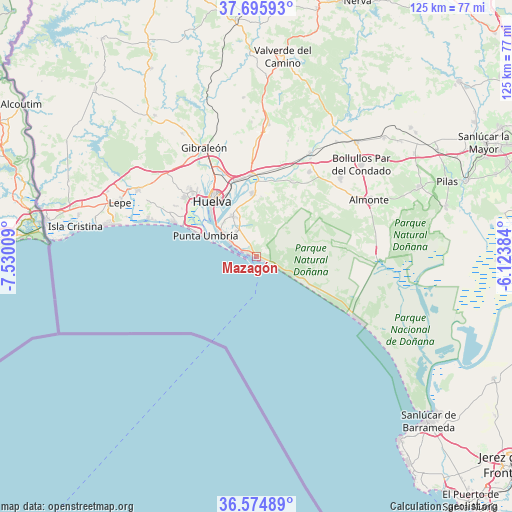
Mazagón GPS coordinates[2]
37° 8' 14.964" North, 6° 49' 37.092" West
| Map corner | latitude | longitude |
|---|---|---|
| Upper-left | 37.69593°, | -7.53009° |
| Center: | 37.13749°, | -6.82697° |
| Lower-right: | 36.57489°, | -6.12384° |
| Map W x H: | 124.6×124.6 km | = 77.4×77.4mi |
| max Lat: | 43.74134° ⇑94.6% North |
| Mazagón: | 37.13749° |
| min Lat: | ⇓5.4% South 27.64134° |
| min Long | Mazagón | max Long |
| -18.00367° | -6.82697° | 4.2899° |
| W 6.3%⇐ | ⇒93.7% E |
Elevation
Elevation of Mazagón is 41 m = 135 ft, and this is 557 m = 1827 ft below average elevation for this country.
| Max E: |
1682 m = 5518 ft | 92.5% |
| Avg. | 598 m = 1962 ft | |
| Mazagón | 41 m = 135 ft | |
Min E: |
0 m = 0 ft | 7.5% |
See also: Spain elevation on elevation.city.
Geographical zone
Mazagón is located in North temperate zone (between Tropic of Cancer and the Arctic Circle). Distance of this Northern Tropic circle is 1523.4 km =946.6 mi to South.| Distance of | km | miles | from Mazagón |
|---|---|---|---|
| North Pole | 5877.8 | 3652.3 | to North |
| Arctic Circle | 3271.9 | 2033.1 | to North |
| Tropic Cancer | 1523.4 | 946.6 | to South |
| Equator | 4129.3 | 2565.8 | to South |


Nearby cities:
15 places around Mazagón: (largest is in red/bold)
• Aljaraque
22.8 km =14.2 mi,  310°
310°
• Almonte
30.9 km =19.2 mi,  62°
62°
• Beas
32.2 km =20 mi,  5°
5°
• Bonares
24.5 km =15.2 mi,  31°
31°
• El Rompido
27.6 km =17.1 mi,  288°
288°
• Gibraleón
29.4 km =18.3 mi,  334°
334°
• Huelva
17.5 km =10.9 mi, 325°
• Lucena del Puerto
20.4 km =12.7 mi, 25°
• Matalascañas
29 km =18 mi,  122°
122°
• Moguer
15.4 km =9.6 mi,  356°
356°
• Niebla
28.2 km =17.5 mi, 27°
• Palos de la Frontera
12.4 km =7.7 mi, 330°
• Punta Umbría
13.3 km =8.3 mi, 291°
• San Juan del Puerto
20 km =12.4 mi, 356°
• Trigueros
27.6 km =17.1 mi,  0°
0°
Sources, notices
• [Note1] Compared only with cities in Spain existing in our database
• [Src1] Map data: © OpenStreetMap contributors (CC-BY-SA)
• [Src2] Other city data from geonames.org with taken over terms of usage.
• [Src3] Geographical zone / Annual Mean Temperature by Robert A. Rohde @ Wikipedia
