Aigües geodata
Aigües (Valencia) is a seat of a third-order administrative division; located in Spain in Europe/Madrid (GMT+2) time zone. In our database, there are 6762 cities with bigger population. Compared to other cities in Spain, 85.7% of cities are located further ↑North; 83.8% of cities are located further ←West and 74.6% of cities have higher elevation than Aigües. Note1


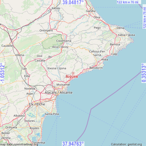
Aigües GPS coordinates[2]
38° 30' 0" North, 0° 21' 0" West
| Map corner | latitude | longitude |
|---|---|---|
| Upper-left | 39.04817°, | -1.05312° |
| Center: | 38.5°, | -0.35° |
| Lower-right: | 37.94763°, | 0.35313° |
| Map W x H: | 122.4×122.4 km | = 76.1×76.1mi |
| max Lat: | 43.74134° ⇑85.7% North |
| Aigües: | 38.5° |
| min Lat: | ⇓14.3% South 27.64134° |
| min Long | Aigües | max Long |
| -18.00367° | -0.35° | 4.2899° |
| W 83.8%⇐ | ⇒16.2% E |
Elevation
Elevation of Aigües is 301 m = 988 ft, and this is 297 m = 974 ft below average elevation for this country.
| Max E: |
1682 m = 5518 ft | 74.6% |
| Avg. | 598 m = 1962 ft | |
| Aigües | 301 m = 988 ft | |
Min E: |
0 m = 0 ft | 25.4% |
See also: Spain elevation on elevation.city.
Geographical zone
Aigües is located in North temperate zone (between Tropic of Cancer and the Arctic Circle). Distance of this Northern Tropic circle is 1674.9 km =1040.7 mi to South.| Distance of | km | miles | from Aigües |
|---|---|---|---|
| North Pole | 5726.3 | 3558.2 | to North |
| Arctic Circle | 3120.4 | 1938.9 | to North |
| Tropic Cancer | 1674.9 | 1040.7 | to South |
| Equator | 4280.8 | 2660 | to South |


Nearby cities:
15 places around Aigües: (largest is in red/bold)
• Benidorm
19.5 km =12.1 mi,  77°
77°
• Benifallim
18.6 km =11.6 mi,  346°
346°
• Busot
6.3 km =3.9 mi,  251°
251°
• El Campello
8.9 km =5.5 mi,  207°
207°
• Finestrat
14.1 km =8.8 mi,  57°
57°
• Jijona
14 km =8.7 mi,  288°
288°
• Mutxamel
12.5 km =7.8 mi,  221°
221°
• Orcheta
10.4 km =6.5 mi,  46°
46°
• Relleu
10.3 km =6.4 mi,  19°
19°
• San Juan de Alicante
13.3 km =8.3 mi, 214°
• San Vicent del Raspeig
19.1 km =11.9 mi,  232°
232°
• Sella
13.9 km =8.6 mi,  28°
28°
• Tibi
20.1 km =12.5 mi,  279°
279°
• Torremanzanas
13.3 km =8.3 mi,  333°
333°
• Villajoyosa
10.2 km =6.3 mi,  85°
85°
Sources, notices
• [Note1] Compared only with cities in Spain existing in our database
• [Src1] Map data: © OpenStreetMap contributors (CC-BY-SA)
• [Src2] Other city data from geonames.org with taken over terms of usage.
• [Src3] Geographical zone / Annual Mean Temperature by Robert A. Rohde @ Wikipedia
