Villajoyosa geodata
Villajoyosa (Valencia) is a seat of a third-order administrative division; located in Spain in Europe/Madrid (GMT+2) time zone. With population of 33,797 people, there are 264 cities with bigger population in this country. Compared to other cities in Spain, 85.6% of cities are located further ↑North; 85.2% of cities are located further ←West and 92.9% of cities have higher elevation than Villajoyosa. Note1


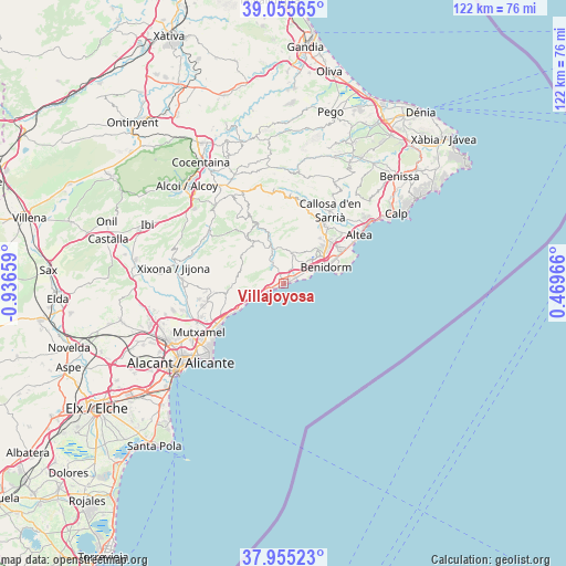
Villajoyosa GPS coordinates[2]
38° 30' 27.144" North, 0° 14' 0.456" West
| Map corner | latitude | longitude |
|---|---|---|
| Upper-left | 39.05565°, | -0.93659° |
| Center: | 38.50754°, | -0.23346° |
| Lower-right: | 37.95523°, | 0.46966° |
| Map W x H: | 122.4×122.4 km | = 76.1×76.1mi |
| max Lat: | 43.74134° ⇑85.6% North |
| Villajoyosa: | 38.50754° |
| min Lat: | ⇓14.4% South 27.64134° |
| min Long | Villajoyosa | max Long |
| -18.00367° | -0.23346° | 4.2899° |
| W 85.2%⇐ | ⇒14.8% E |
Elevation
Elevation of Villajoyosa is 39 m = 128 ft, and this is 559 m = 1834 ft below average elevation for this country.
| Max E: |
1682 m = 5518 ft | 92.9% |
| Avg. | 598 m = 1962 ft | |
| Villajoyosa | 39 m = 128 ft | |
Min E: |
0 m = 0 ft | 7.1% |
See also: Spain elevation on elevation.city.
Geographical zone
Villajoyosa is located in North temperate zone (between Tropic of Cancer and the Arctic Circle). Distance of this Northern Tropic circle is 1675.7 km =1041.2 mi to South.| Distance of | km | miles | from Villajoyosa |
|---|---|---|---|
| North Pole | 5725.4 | 3557.6 | to North |
| Arctic Circle | 3119.5 | 1938.4 | to North |
| Tropic Cancer | 1675.7 | 1041.2 | to South |
| Equator | 4281.6 | 2660.5 | to South |


Nearby cities:
15 places around Villajoyosa: (largest is in red/bold)
• Aigües
10.2 km =6.3 mi,  265°
265°
• Altea
18.8 km =11.7 mi,  57°
57°
• Benidorm
9.5 km =5.9 mi,  69°
69°
• Benimantell
19 km =11.8 mi,  6°
6°
• Busot
16.4 km =10.2 mi,  260°
260°
• Callosa d'En Sarrià
18.8 km =11.7 mi,  32°
32°
• El Campello
16.8 km =10.4 mi,  238°
238°
• Finestrat
6.9 km =4.3 mi,  15°
15°
• Orcheta
6.8 km =4.2 mi,  337°
337°
• Polop
15.6 km =9.7 mi, 34°
• Relleu
11.2 km =7 mi,  322°
322°
• Sella
11.8 km =7.3 mi, 343°
• Torremanzanas
19.5 km =12.1 mi,  304°
304°
• l'Alfàs del Pi
13.9 km =8.6 mi,  54°
54°
• la Nucia
15 km =9.3 mi,  38°
38°
Sources, notices
• [Note1] Compared only with cities in Spain existing in our database
• [Src1] Map data: © OpenStreetMap contributors (CC-BY-SA)
• [Src2] Other city data from geonames.org with taken over terms of usage.
• [Src3] Geographical zone / Annual Mean Temperature by Robert A. Rohde @ Wikipedia
