El Campello geodata
El Campello (Valencia) is a populated place; located in Spain in Europe/Madrid (GMT+2) time zone. With population of 26,511 people, there are 352 cities with bigger population in this country. Compared to other cities in Spain, 86% of cities are located further ↑North; 83.2% of cities are located further ←West and 95.1% of cities have higher elevation than El Campello. Note1


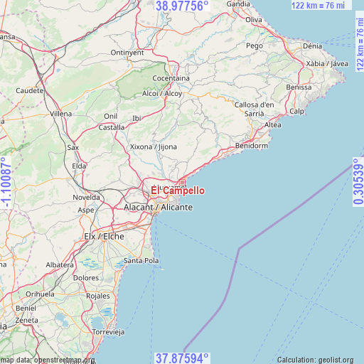
El Campello GPS coordinates[2]
38° 25' 43.86" North, 0° 23' 51.864" West
| Map corner | latitude | longitude |
|---|---|---|
| Upper-left | 38.97756°, | -1.10087° |
| Center: | 38.42885°, | -0.39774° |
| Lower-right: | 37.87594°, | 0.30539° |
| Map W x H: | 122.5×122.5 km | = 76.1×76.1mi |
| max Lat: | 43.74134° ⇑86% North |
| El Campello: | 38.42885° |
| min Lat: | ⇓14% South 27.64134° |
| min Long | El Campello | max Long |
| -18.00367° | -0.39774° | 4.2899° |
| W 83.2%⇐ | ⇒16.8% E |
Elevation
Elevation of El Campello is 24 m = 79 ft, and this is 574 m = 1883 ft below average elevation for this country.
| Max E: |
1682 m = 5518 ft | 95.1% |
| Avg. | 598 m = 1962 ft | |
| El Campello | 24 m = 79 ft | |
Min E: |
0 m = 0 ft | 4.9% |
See also: Spain elevation on elevation.city.
Geographical zone
El Campello is located in North temperate zone (between Tropic of Cancer and the Arctic Circle). Distance of this Northern Tropic circle is 1667 km =1035.8 mi to South.| Distance of | km | miles | from El Campello |
|---|---|---|---|
| North Pole | 5734.2 | 3563.1 | to North |
| Arctic Circle | 3128.3 | 1943.8 | to North |
| Tropic Cancer | 1667 | 1035.8 | to South |
| Equator | 4272.9 | 2655.1 | to South |


Nearby cities:
15 places around El Campello: (largest is in red/bold)
• Agost
21 km =13 mi,  273°
273°
• Aigües
8.9 km =5.5 mi,  27°
27°
• Alicante
11.8 km =7.3 mi,  218°
218°
• Busot
6.2 km =3.9 mi,  342°
342°
• Finestrat
22.3 km =13.9 mi,  46°
46°
• Jijona
15.4 km =9.6 mi,  323°
323°
• Mutxamel
4.4 km =2.7 mi,  250°
250°
• Orcheta
19.1 km =11.9 mi,  37°
37°
• Relleu
19.1 km =11.9 mi,  23°
23°
• San Juan de Alicante
4.5 km =2.8 mi,  227°
227°
• San Vicent del Raspeig
11.7 km =7.3 mi, 252°
• Sella
22.8 km =14.2 mi, 28°
• Tibi
19.3 km =12 mi,  305°
305°
• Torremanzanas
19.8 km =12.3 mi,  354°
354°
• Villajoyosa
16.8 km =10.4 mi,  58°
58°
Sources, notices
• [Note1] Compared only with cities in Spain existing in our database
• [Src1] Map data: © OpenStreetMap contributors (CC-BY-SA)
• [Src2] Other city data from geonames.org with taken over terms of usage.
• [Src3] Geographical zone / Annual Mean Temperature by Robert A. Rohde @ Wikipedia
