Relleu geodata
Relleu (Valencia) is a seat of a third-order administrative division; located in Spain in Europe/Madrid (GMT+2) time zone. With population of 987 people, there are 2969 cities with bigger population in this country. Compared to other cities in Spain, 85.1% of cities are located further ↑North; 84.4% of cities are located further ←West and 67.1% of cities have higher elevation than Relleu. Note1


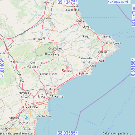
Relleu GPS coordinates[2]
38° 35' 14.1" North, 0° 18' 41.652" West
| Map corner | latitude | longitude |
|---|---|---|
| Upper-left | 39.13475°, | -1.01469° |
| Center: | 38.58725°, | -0.31157° |
| Lower-right: | 38.03555°, | 0.39156° |
| Map W x H: | 122.2×122.2 km | = 75.9×75.9mi |
| max Lat: | 43.74134° ⇑85.1% North |
| Relleu: | 38.58725° |
| min Lat: | ⇓14.9% South 27.64134° |
| min Long | Relleu | max Long |
| -18.00367° | -0.31157° | 4.2899° |
| W 84.4%⇐ | ⇒15.6% E |
Elevation
Elevation of Relleu is 431 m = 1414 ft, and this is 167 m = 548 ft below average elevation for this country.
| Max E: |
1682 m = 5518 ft | 67.1% |
| Avg. | 598 m = 1962 ft | |
| Relleu | 431 m = 1414 ft | |
Min E: |
0 m = 0 ft | 32.9% |
See also: Spain elevation on elevation.city.
Geographical zone
Relleu is located in North temperate zone (between Tropic of Cancer and the Arctic Circle). Distance of this Northern Tropic circle is 1684.6 km =1046.8 mi to South.| Distance of | km | miles | from Relleu |
|---|---|---|---|
| North Pole | 5716.6 | 3552.1 | to North |
| Arctic Circle | 3110.7 | 1932.9 | to North |
| Tropic Cancer | 1684.6 | 1046.8 | to South |
| Equator | 4290.5 | 2666 | to South |


Nearby cities:
15 places around Relleu: (largest is in red/bold)
• Aigües
10.3 km =6.4 mi,  199°
199°
• Benasau
11.8 km =7.3 mi,  346°
346°
• Beniardá
13.6 km =8.5 mi,  37°
37°
• Benifallim
11.4 km =7.1 mi,  317°
317°
• Benilloba
14.3 km =8.9 mi,  331°
331°
• Benimantell
13.3 km =8.3 mi, 41°
• Busot
15 km =9.3 mi,  218°
218°
• Confrides
11.4 km =7.1 mi,  18°
18°
• Finestrat
8.9 km =5.5 mi,  104°
104°
• Gorga
15.1 km =9.4 mi, 345°
• Orcheta
5 km =3.1 mi,  121°
121°
• Polop
16.2 km =10.1 mi,  75°
75°
• Sella
4.1 km =2.5 mi,  53°
53°
• Torremanzanas
9.5 km =5.9 mi,  282°
282°
• Villajoyosa
11.2 km =7 mi,  142°
142°
Sources, notices
• [Note1] Compared only with cities in Spain existing in our database
• [Src1] Map data: © OpenStreetMap contributors (CC-BY-SA)
• [Src2] Other city data from geonames.org with taken over terms of usage.
• [Src3] Geographical zone / Annual Mean Temperature by Robert A. Rohde @ Wikipedia
