Busot geodata
Busot (Valencia) is a seat of a third-order administrative division; located in Spain in Europe/Madrid (GMT+2) time zone. With population of 2,272 people, there are 2015 cities with bigger population in this country. Compared to other cities in Spain, 85.8% of cities are located further ↑North; 82.8% of cities are located further ←West and 72.9% of cities have higher elevation than Busot. Note1


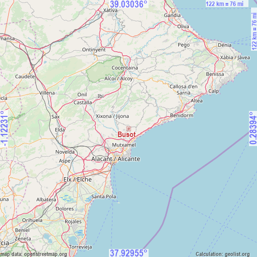
Busot GPS coordinates[2]
38° 28' 55.416" North, 0° 25' 9.048" West
| Map corner | latitude | longitude |
|---|---|---|
| Upper-left | 39.03036°, | -1.12231° |
| Center: | 38.48206°, | -0.41918° |
| Lower-right: | 37.92955°, | 0.28394° |
| Map W x H: | 122.4×122.4 km | = 76.1×76.1mi |
| max Lat: | 43.74134° ⇑85.8% North |
| Busot: | 38.48206° |
| min Lat: | ⇓14.2% South 27.64134° |
| min Long | Busot | max Long |
| -18.00367° | -0.41918° | 4.2899° |
| W 82.8%⇐ | ⇒17.2% E |
Elevation
Elevation of Busot is 334 m = 1096 ft, and this is 264 m = 866 ft below average elevation for this country.
| Max E: |
1682 m = 5518 ft | 72.9% |
| Avg. | 598 m = 1962 ft | |
| Busot | 334 m = 1096 ft | |
Min E: |
0 m = 0 ft | 27.1% |
See also: Spain elevation on elevation.city.
Geographical zone
Busot is located in North temperate zone (between Tropic of Cancer and the Arctic Circle). Distance of this Northern Tropic circle is 1672.9 km =1039.5 mi to South.| Distance of | km | miles | from Busot |
|---|---|---|---|
| North Pole | 5728.3 | 3559.4 | to North |
| Arctic Circle | 3122.4 | 1940.2 | to North |
| Tropic Cancer | 1672.9 | 1039.5 | to South |
| Equator | 4278.8 | 2658.7 | to South |


Nearby cities:
15 places around Busot: (largest is in red/bold)
• Agost
19.6 km =12.2 mi,  256°
256°
• Aigües
6.3 km =3.9 mi,  71°
71°
• Alicante
16.2 km =10.1 mi,  199°
199°
• Benifallim
20.1 km =12.5 mi,  4°
4°
• El Campello
6.2 km =3.9 mi,  162°
162°
• Jijona
9.8 km =6.1 mi,  312°
312°
• Mutxamel
7.7 km =4.8 mi, 197°
• Orcheta
16.4 km =10.2 mi,  56°
56°
• Relleu
15 km =9.3 mi,  38°
38°
• San Juan de Alicante
9.1 km =5.7 mi,  189°
189°
• San Vicent del Raspeig
13.3 km =8.3 mi,  224°
224°
• Sella
19 km =11.8 mi, 41°
• Tibi
14.8 km =9.2 mi,  291°
291°
• Torremanzanas
13.8 km =8.6 mi, 0°
• Villajoyosa
16.4 km =10.2 mi,  80°
80°
Sources, notices
• [Note1] Compared only with cities in Spain existing in our database
• [Src1] Map data: © OpenStreetMap contributors (CC-BY-SA)
• [Src2] Other city data from geonames.org with taken over terms of usage.
• [Src3] Geographical zone / Annual Mean Temperature by Robert A. Rohde @ Wikipedia
