Orcheta geodata
Orcheta (Valencia) is a populated place; located in Spain in Europe/Madrid (GMT+2) time zone. With population of 1,303 people, there are 2642 cities with bigger population in this country. Compared to other cities in Spain, 85.3% of cities are located further ↑North; 85% of cities are located further ←West and 81.3% of cities have higher elevation than Orcheta. Note1


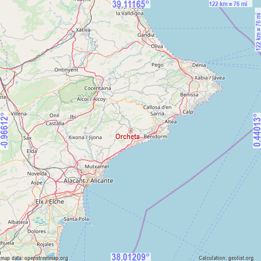
Orcheta GPS coordinates[2]
38° 33' 50.292" North, 0° 15' 46.764" West
| Map corner | latitude | longitude |
|---|---|---|
| Upper-left | 39.11165°, | -0.96612° |
| Center: | 38.56397°, | -0.26299° |
| Lower-right: | 38.01209°, | 0.44013° |
| Map W x H: | 122.3×122.3 km | = 76×76mi |
| max Lat: | 43.74134° ⇑85.3% North |
| Orcheta: | 38.56397° |
| min Lat: | ⇓14.7% South 27.64134° |
| min Long | Orcheta | max Long |
| -18.00367° | -0.26299° | 4.2899° |
| W 85%⇐ | ⇒15% E |
Elevation
Elevation of Orcheta is 198 m = 650 ft, and this is 400 m = 1312 ft below average elevation for this country.
| Max E: |
1682 m = 5518 ft | 81.3% |
| Avg. | 598 m = 1962 ft | |
| Orcheta | 198 m = 650 ft | |
Min E: |
0 m = 0 ft | 18.7% |
See also: Spain elevation on elevation.city.
Geographical zone
Orcheta is located in North temperate zone (between Tropic of Cancer and the Arctic Circle). Distance of this Northern Tropic circle is 1682 km =1045.1 mi to South.| Distance of | km | miles | from Orcheta |
|---|---|---|---|
| North Pole | 5719.2 | 3553.7 | to North |
| Arctic Circle | 3113.3 | 1934.5 | to North |
| Tropic Cancer | 1682 | 1045.1 | to South |
| Equator | 4287.9 | 2664.4 | to South |


Nearby cities:
15 places around Orcheta: (largest is in red/bold)
• Aigües
10.4 km =6.5 mi,  226°
226°
• Benasau
15.7 km =9.8 mi,  333°
333°
• Beniardá
14 km =8.7 mi,  16°
16°
• Benidorm
11.8 km =7.3 mi,  104°
104°
• Benimantell
13.4 km =8.3 mi, 19°
• Callosa d'En Sarrià
15.9 km =9.9 mi,  53°
53°
• Confrides
13.4 km =8.3 mi,  357°
357°
• Finestrat
4.4 km =2.7 mi,  85°
85°
• Polop
13.2 km =8.2 mi,  60°
60°
• Relleu
5 km =3.1 mi,  301°
301°
• Sella
5.1 km =3.2 mi,  350°
350°
• Torremanzanas
14.3 km =8.9 mi,  289°
289°
• Villajoyosa
6.8 km =4.2 mi,  157°
157°
• l'Alfàs del Pi
14 km =8.7 mi,  82°
82°
• la Nucia
13.1 km =8.1 mi, 64°
Sources, notices
• [Note1] Compared only with cities in Spain existing in our database
• [Src1] Map data: © OpenStreetMap contributors (CC-BY-SA)
• [Src2] Other city data from geonames.org with taken over terms of usage.
• [Src3] Geographical zone / Annual Mean Temperature by Robert A. Rohde @ Wikipedia
