Zael geodata
Zael (Castille and León) is a seat of a third-order administrative division; located in Spain in Europe/Madrid (GMT+2) time zone. With population of 126 people, there are 5628 cities with bigger population in this country. Compared to other cities in Spain, 76.7% of cities are located further ↓South; 57.3% of cities are located further →East and 73.8% of cities have lower elevation than Zael. Note1


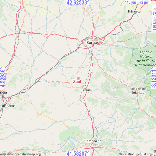
Zael GPS coordinates[2]
42° 6' 21.132" North, 3° 49' 34.428" West
| Map corner | latitude | longitude |
|---|---|---|
| Upper-left | 42.62538°, | -4.52936° |
| Center: | 42.10587°, | -3.82623° |
| Lower-right: | 41.58207°, | -3.12311° |
| Map W x H: | 116×116 km | = 72.1×72.1mi |
| max Lat: | 43.74134° ⇑23.3% North |
| Zael: | 42.10587° |
| min Lat: | ⇓76.7% South 27.64134° |
| min Long | Zael | max Long |
| -18.00367° | -3.82623° | 4.2899° |
| W 42.7%⇐ | ⇒57.3% E |
Elevation
Elevation of Zael is 842 m = 2762 ft, and this is 244 m = 801 ft above average elevation for this country.
| Max E: |
1682 m = 5518 ft | 26.2% |
| Zael | 842 m 2762 ft | |
| Avg. | 598 m = 1962 ft | |
Min E: |
0 m = 0 ft | 73.8% |
See also: Spain elevation on elevation.city.
Geographical zone
Zael is located in North temperate zone (between Tropic of Cancer and the Arctic Circle). Distance of this Northern Tropic circle is 2075.8 km =1289.8 mi to South.| Distance of | km | miles | from Zael |
|---|---|---|---|
| North Pole | 5325.3 | 3309 | to North |
| Arctic Circle | 2719.4 | 1689.8 | to North |
| Tropic Cancer | 2075.8 | 1289.8 | to South |
| Equator | 4681.7 | 2909.1 | to South |


Nearby cities:
15 places around Zael: (largest is in red/bold)
• Ciadoncha
10.5 km =6.5 mi,  303°
303°
• Lerma
10.4 km =6.5 mi,  148°
148°
• Madrigalejo del Monte
8.6 km =5.3 mi,  76°
76°
• Mahamud
9.6 km =6 mi,  279°
279°
• Presencio
10.9 km =6.8 mi,  325°
325°
• Santa Cecilia
6.3 km =3.9 mi,  162°
162°
• Santa Inés
12.5 km =7.8 mi,  125°
125°
• Tordómar
7.4 km =4.6 mi,  205°
205°
• Torrecilla del Monte
11 km =6.8 mi,  96°
96°
• Valdorros
12.1 km =7.5 mi,  52°
52°
• Villahoz
7.9 km =4.9 mi,  244°
244°
• Villalmanzo
9.4 km =5.8 mi, 132°
• Villamayor de los Montes
5 km =3.1 mi,  90°
90°
• Villangómez
9.3 km =5.8 mi,  27°
27°
• Villaverde del Monte
6.2 km =3.9 mi,  9°
9°
Sources, notices
• [Note1] Compared only with cities in Spain existing in our database
• [Src1] Map data: © OpenStreetMap contributors (CC-BY-SA)
• [Src2] Other city data from geonames.org with taken over terms of usage.
• [Src3] Geographical zone / Annual Mean Temperature by Robert A. Rohde @ Wikipedia
